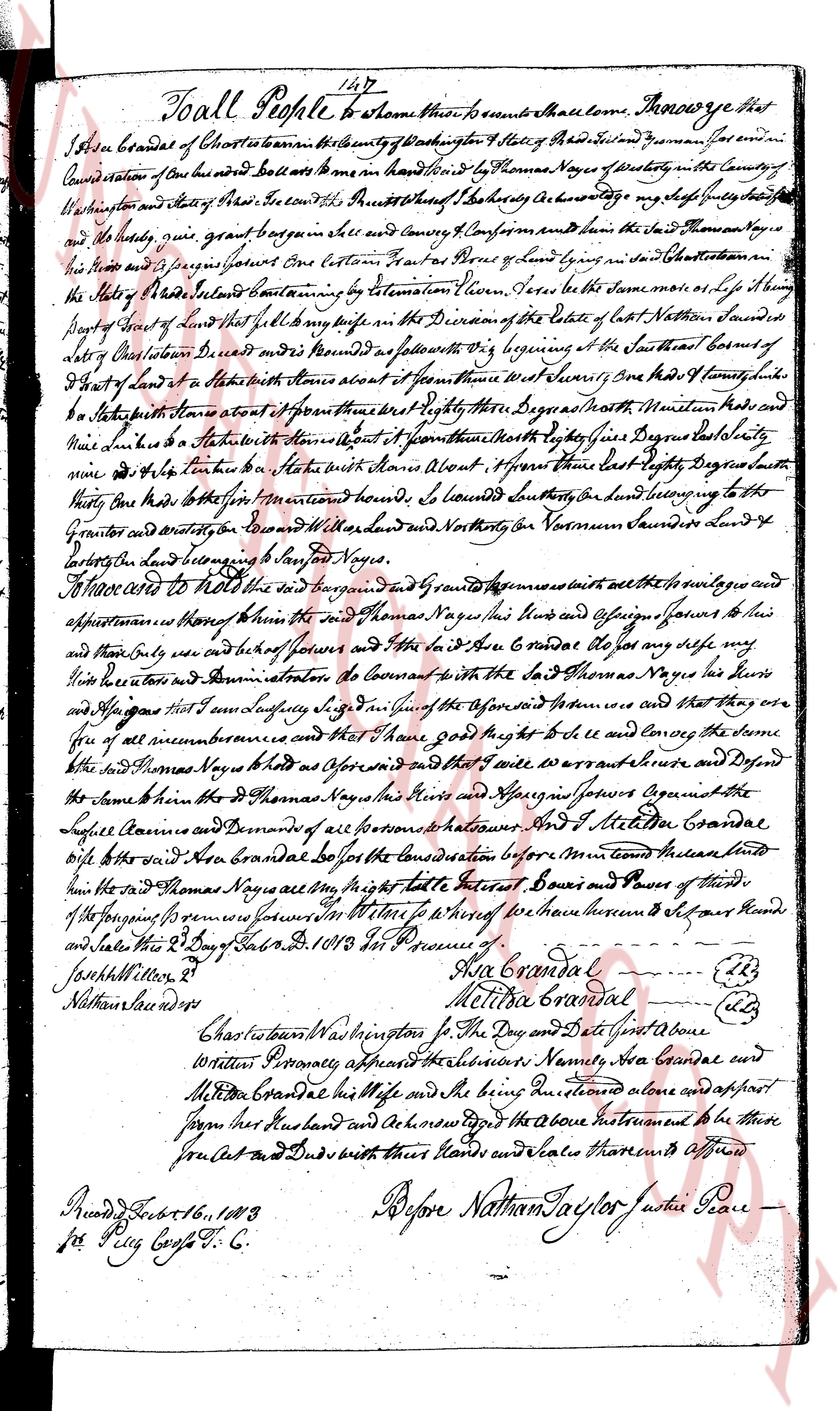
The instrument's own words
page 1
To all People to know that these presents shall come. Know ye that
I Asa Crandall of Charlestown in the county of Washington State of Rhode Island and Providence
County resident of the same had and still have in my hand by the Thomas Noyes of Westerly in the County of
Washington and State of Rhode Island the Indenture dated the twenty sixth day of July 1784 between my self Asa Crandall
and the said Thomas Noyes given in the said County of Providence and known him the said Thomas Noyes
his heirs and assigns forever by one Certain Lot of Land lying in the said Town of Charlestown in
the said State of Rhode Island containing by estimation Eleven Acres the same be the same more or less lying
by the part of Land of said Thomas Noyes in the District of the East of late Nathan Saunders and is
laid off Constitution District and is bounded as follows to wit Beginning at the southeast corner of
a Lot of Lands of Asa Crandall with his heirs alone of approximately seven feet and running West one hundred & seventy
five feet to a Stake with stone about 4 feet and running North eighty three degrees North west one hundred
nine links to a Stake with stone about 4 feet and running North eighty four degrees East ninety
nine & a half links to a Stake with stone about 4 feet and running East eighty degrees North west one hundred
fifty five links to the first mentioned bounds so bounded southly on land belonging to the said
Governor Wanton and bounded East by land of [illegible] and North by Norman Saunders land 4
acres lying on the land belonging to said Thomas Noyes.
I now accede to hold the said land bargained and granted premises with all the heritages and
appurtenances thereof knowing that I and Thomas Noyes his heirs and assigns forever to his
and theirs only and not to the heirs and forever of any other to the said Thomas Noyes the said my
self Asa Crandall and assigns forever do Covenant to the wit that I and the said Thomas Noyes his heirs
and assigns forever shall have sandy lying in the aforesaid Lot of land that they are
free of all encumbrances and that I shall give full and convey the same and I warrant seize and Defend
the same against the said Thomas Noyes his heirs and assigns forever against the
Legal Claims and Demands of all persons whomsoever And I Setelahon Crandall
wife to the said Asa Crandall be for the consideration before mentioned leave unto
him the said Thomas Noyes his heirs and assigns forever the right title Interest Power and power of third
of the forging premises for whomsoever witness whereof have thereunto set their hands
and Seals this 3 Day of Sept 1810 In Presence of
Joseph Millon Jr
Nathaniel Dewe
Asa Crandall
Melitta Crandall
Charlestown Washington St. the Day and Date just above
Written Personally acknowledged before me the subscribers Namely Asa Crandall and
Melitta Crandall his wife and the being husband and acknowledged
signed here his husband and acknowledged the above instrument to be their
free Act and Deed with their hands and seals therefore affirmed
Before Nathan Taylor Justice of Peace
Recorded Feb 16, 1813
per Peg Cost F. C.
The page as recorded