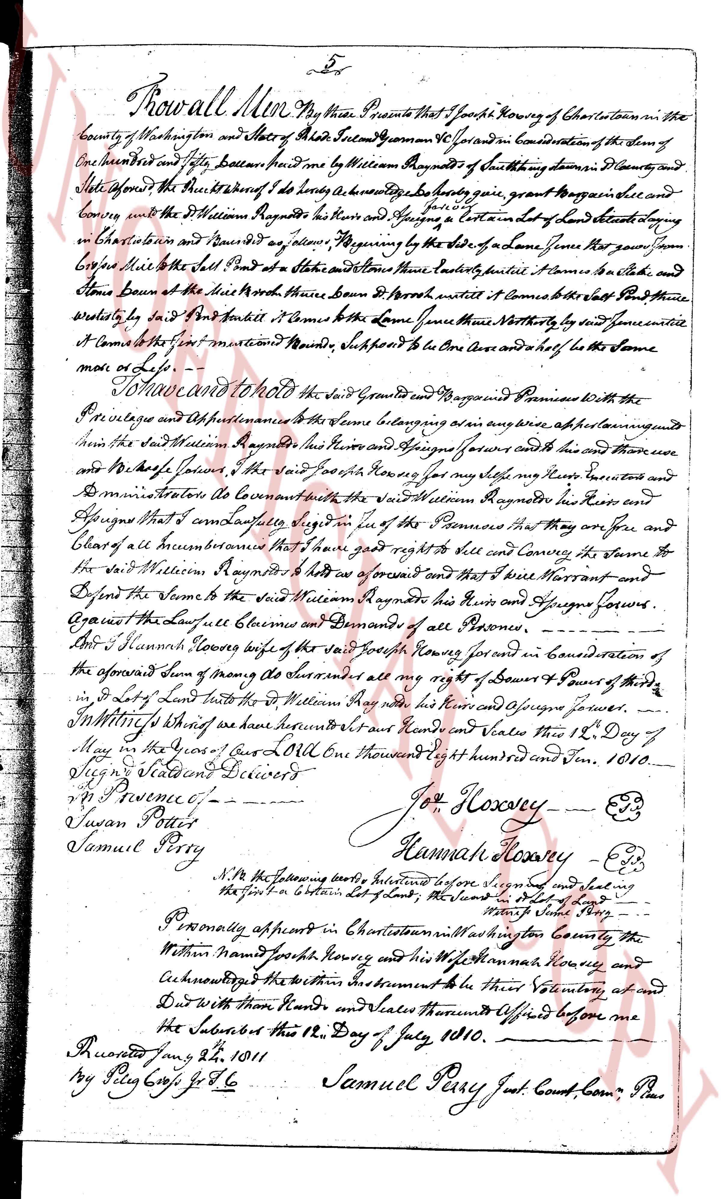
The instrument's own words
page 1
Know all Men by these Presents that I Joseph Hoxsey of Charlestown in the
county of Washington and State of Rhode Island townman 46 years in Consideration of the Sum of
One hundred and eight dollars paid unto me by William Raymond of said towny district of County
and State aforesaid the Receipt whereof I do hereby acknowledge to be truly given grant bargain sell and
convey unto the said William Raymond his heirs and Assigns a certain lot of land situated lying
in Charlestown and known as jl’s farm bounding by the side of some years past known
Common Hill to the South Poll at the Statue and Stone there called some Pile of Stone and
Stone bound of the North with three Don’s of Brush until it Comes to the said South Poll there
bounded by a ditch and Brook it Comes to the Same there Northesterly to said fence until it
it Comes to the first marked boundary supposed to be One Acre and a half to the Same
more or less.
To have and to hold the said Ground and Bargained Premises with the
the Privileges and Appurtenances thereunto belonging as well as any other appurtenances
in the said William Raymond his heirs and Assigns forever and the same there
and Moreover I the said Joseph Hoxsey for my self my heirs my heirs executors and
Omnia Successors do Covenant the said William Raymond his heirs and
Assigns that I am lawfully seized in right of the Premises that they are free and
Clear of all encumbrances that I have good right to title and Convey the same to
the said William Raymond his heirs as aforesaid and that I will Warrant and
Defend the same to the said William Raymond his heirs and Assigns forever
Against the Lawfull claims and Demands of all Persons
I said Hannah Hoxsey wife of the said Joseph Hoxsey for and in Consideration of
the aforesaid Sum of money of all aforesaid all my right of Device and Pure of the
in said Lot of Land unto the said William Raymond his heirs and Assigns forever.
In Witness whereof we have hereunto set our hands and Seals this 12th Day of
May in the Year of Our Lord One thousand Eight hundred and ten. 1810.
Signed Witnessed and Delivered
p. Pruence
Susan Perry
Samuel Perry
Joseph Hoxsey (seal)
Hannah Hoxsey (seal)
N.B. the following boundary relates before Signed and sealing
the certain in certain Lot of Land, the Land of [illegible]
[illegible]
Personally appeared in Charlestown in Washington County the
Within named Joseph Hoxsey and his Wife Hannah Hoxsey and
Acknowledged the within Instrument to be Their voluntary act and
Deed With their Hands and Seals aforesaid certified before me
the Subscriber this 18th Day of July, 1810.
Recorded Jany 21st 1811
by Ply Crys for T.C.
Samuel Perry Just. Court Comr Plas
The page as recorded