The Deed Walker · From Ninigret · Charlestown, Rhode Island land evidence, 1738 to today
Trail: 6498 › 18@27/519 › 115@27/322

5/21/1938 · DEED · book 27 page 322 doc 115@27/322

From KENYON FRED H life, KENYON MAUDE B
To KENYON MAUDE B, KENYON FRED H life
Premises approximately three acres more or less · real estate with buildings and improvements (Charlestown, Galilee, North shore River Jamestown, Pawcatuck River)
Index description SEE DOC

Back — where this land came from

This instrument states no source of title that we have read yet.

The grantor's earlier acquisitions, by name — the man, not necessarily this land

◀ 1938 · DEED · GARDINER EDNA M; GARDINER WILLIAM J → KENYON FRED H · book 27 p 271
◀ 1935 · DEED · TUCKER MILLARD F → POTTER MYRA; KENYON FRED H; KENYON MAUDE B; POTTER HAROLD · book 26 p 49
◀ 1938 · DEED · KING CHARLES; KING MARIE LEA → KENYON FRED H · book 27 p 393
◀ 1938 · DEED · DYSON CHARLES H; DYSON HAZEL H → KENYON FRED H · book 27 p 393
◀ 1926 · DEED · BURDICK MARION G; BURDICK EDWARD E → KENYON FRED H; KENYON MAUDE B · book 22 p 357
◀ 1910 · DEED · KENYON FRANK I; KENYON LOUISE C → KENYON FRED H · book 16 p 430
◀ 1910 · DEED · KENYON REBA V BY GUARDIAN → KENYON FRED H · book 16 p 439

Forward — where this land went

The grantee's later conveyances, by name — the man, not necessarily this land; the one that cites this deed as its source is the land

▶ 1938 · DEED · KENYON FRED H; KENYON MAUDE B → WRIGHT HELEN M · book 27 p 220
▶ 1938 · DEED · KENYON FRED H; KENYON MAUDE B → HOLMAN HORACE A; HOLMAN ALICE M · book 27 p 237
▶ 1938 · DEED · KENYON FRED H; KENYON MAUDE B → GARDINER EDNA M; GARDINER WILLIAM J · book 27 p 272
▶ 1938 · DEED · KENYON FRED H; KENYON MAUDE B → BARBER MYRTLE; BARBER WILLIAM P G · book 27 p 274
▶ 1938 · DEED · KENYON FRED H; KENYON MAUDE B → BARBER MYRTLE E · book 27 p 275
▶ 1938 · DEED · KENYON FRED H; KENYON MAUDE B → JORDAN JOHN S; HORDAN JULIA A; JORDAN JULIA A · book 27 p 277
▶ 1938 · DEED · KENYON FRED H; KENYON MAUDE B → WESTON GEORGE W; WESTON HAZEL I; GAVITT HANNAH A; GAVITT GEORGE E · book 27 p 289
▶ 1938 · DEED · KENYON FRED H; KENYON MAUDE B → KING CHARLES; KING MARIE LEA · book 27 p 394
▶ 1938 · DEED · KENYON FRED H; KENYON MAUDE B → DYSON CHARLES H; DYSON HAZEL H · book 27 p 396
▶ 1939 · DEED · KENYON FRED H; KENYON MAUDE B → DYSON CHARLES H; DYSON HAZEL H · book 27 p 519
▶ 1939 · DEED · KENYON FRED H; KENYON MAUDE B → TOUGAS MARIE R; TOUGAS VICTOR · book 28 p 92
▶ 1940 · DEED · KENYON FRED H; KENYON MAUDE B → KING CHARLES; KING MARIE LEA · book 28 p 251
▶ 1940 · DEED · KENYON FRED H; KENYON MAUDE B → DYSON CHARLES H; DYSON HAZEL H · book 28 p 252
▶ 1940 · DEED · KENYON FRED H; KENYON MAUDE H → TOUGAS MARIE B; TOUGAS VICTOR · book 28 p 264
▶ 1940 · DEED · KENYON FRED H; KENYON MAUDE B → TOUGAS MARIE R; TOUGAS VICTOR · book 28 p 328
▶ 1940 · DEED · KENYON FRED H; KENYON MAUDE B → MELBOURNE FLORENCE C; MELBOURNE IRVING R · book 28 p 365

The instrument's own words

page 1
322 I, FRED H. KENTON, of the Town of Charlestown, County of Washington, State of Rhode Island, for consideration paid, grant to myself, Fred H. Kenton, and to my Wife, Maude B. Kenton, of said Town, County and State, as joint tenants with the rights of survivorship and not as tenants in common, with QUIET-CLAIM COVENANTS That certain real estate, together with the buildings and improvements thereon, sit- uated in the Town of Charlestown, County of Washington, State of Rhode Island, bounded and de- scribed as follows: Beginning at a point on or near the northerly side of the State Highway leading from the village of Galilee to North shore River Jamestown either side pointing the south- easterly corner of the premises hereby conveyed and the southwesterly corner of the premises of Penrose L. Tuttle; thence running in a southwesterly direction said point being the south- eastly corner of premises of Myrtle L. Barker; thence running southerly, bounded westerly by said Maude B. Kenton; thence running in a northeasterly direction and following the east side of Pawcatuck River to a point where said River runs in a northwesterly direction, direction bounded partly by land of said Charles King, et ux and partly by land formerly of William S. Tuttle; thence running in a northerly direction, private path former boundary of the westerly boundary line of said Pawcatuck River; thence southerly, bounded easterly by said Pawcatuck River to the point of beginning, containing approximately three acres more or less bounded or described. Excepting, however, from the above-described premises, three parcels or tracts of land, conveyed from this Grantor to Charles King, et ux, by deed Dated September 10, 1927 and recorded in the Records of Land Evidence, said Town of Charlestown, in Book No. 27, at Page 189; another parcel conveyed from this Grantor to Charles King, et ux, by deed recorded in said Land Evidence Records, in Book No. 27, at Page 221 also, by deed stating at Page 189, another parcel conveyed from this Grantor to Charles King, et ux, by deed recorded in Book 27, at Page 272 also, by deed, bearing date of March 19, 1938, to John S. Jordan, et ux, recorded in said Land Evidence Records in Book 27, at Page 271 also, by deed, bearing date of March 23, 1938, to George W. Washburn, et al recorded said Land Evidence in Book 27, at Page 269. I, MAUDE B. KENTON, wife of the Grantor, Fred H. Kenton, release to the grantees all my right of dower and all other interest in the aforementioned premises. WITNESS our hands this 21st day of May, 1953. FRED H. KENTON MAUDE B. KENTON STATE OF RHODE ISLAND) County of Washington ) In Charlestown, on the 21st day of May, A. D. 1953, before me personally appeared Fred H. Kenton and Maude B. Kenton, husband and wife, to me known and known by me to be the parties executing the foregoing instrument, and they acknowledged said instrument, by them executed, to be their free act and deed. LINTON L. BROWN Notary Public. Consideration less than $100.00. Received for record May 21st, A. D. 1953 at 2:00 o'clock, p. m., and recorded by Town Clerk

The page as recorded
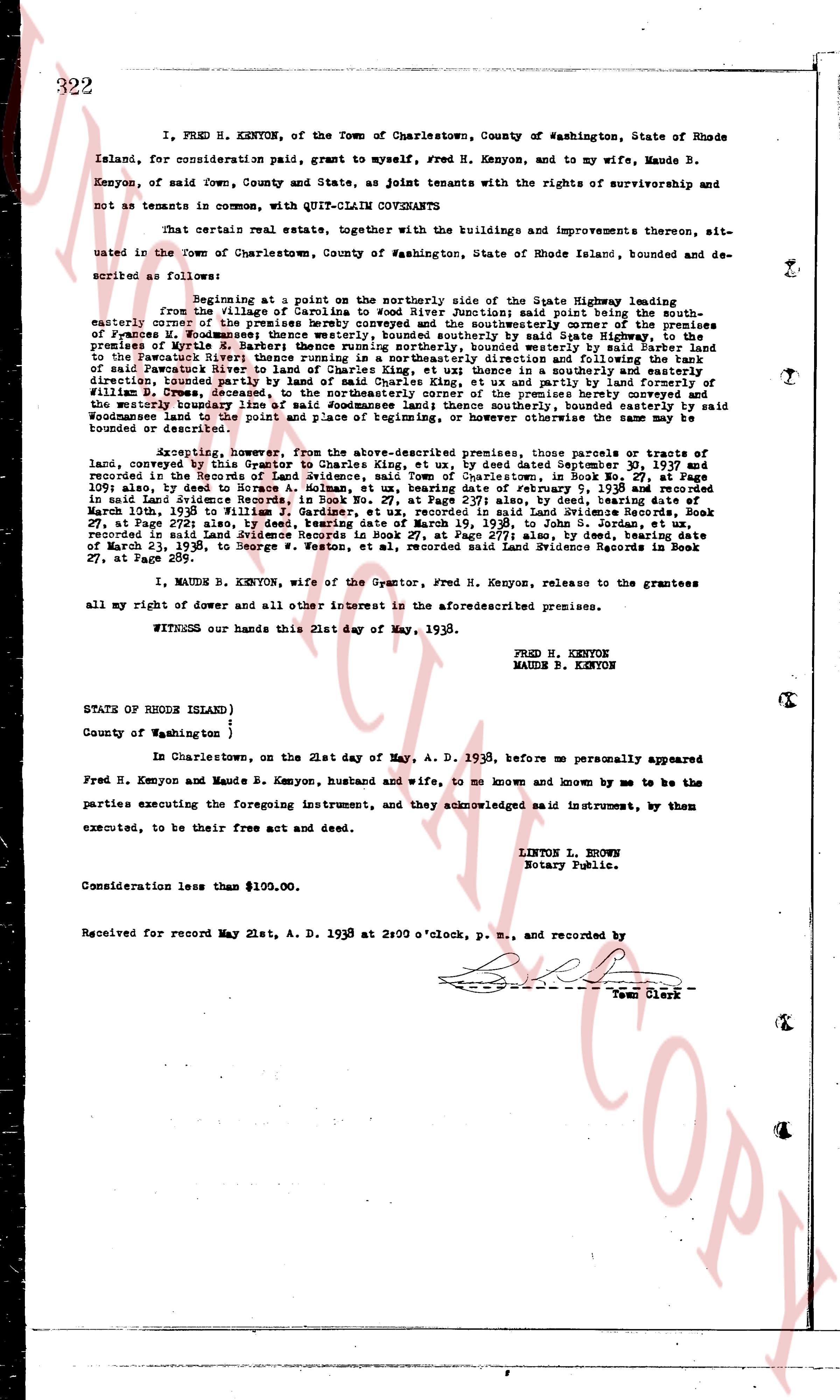
page 1

deed_walker_v1.9_2026-10-10 · the index is the town's own (i2l.uslandrecords.com); transcripts, chains and the assessor's cards are the Perry Machine's reading of it. Where the record we hold runs out, the page says so.