The Deed Walker · From Ninigret · Charlestown, Rhode Island land evidence, 1738 to today
Trail: 1157@29/593

11/10/1945 · DEED · book 29 page 593 doc 1157@29/593

From SAFFORD DORIS E, SAFFORD HARVEY C
To WATTS CHARLES E
Consideration consideration paid
Premises Lots 11, 12, 13, and 14 on Point Meadow Plat (Charlestown, Point Meadow Plat, Pomaget Meadows Plat, Charlestown Beach Road)
Index description LOTS 11-14 POINT MEADOW

Back — where this land came from

deed Louis R. Bell book 223 p 223 Charlestown
“conveyed in warranty to Harvey C. Safford from Louis R. Bell”
the cited instrument is not in the index we hold (not_in_index)
read by: gemma

The grantor's earlier acquisitions, by name — the man, not necessarily this land

◀ 1936 · DEED · FERRIER WINIFRED E H; FERRIER JOHN MOERTON → SAFFORD HARVEY C · book 26 p 423
◀ 1945 · PREL · WAKEFIELD TRUST CO,EX; BELL LOUIS F EST; BELL WILLIAM CLARKE EX → SAFFORD HARVEY C · book 29 p 562
◀ 1945 · PREL · WAKEFIELD TRUST CO,EX; BELL LOUIS F EST; BELL WILLIAM CLARKE EX → SAFFORD HARVEY C · book 29 p 563
◀ 1945 · PREL · CAMPBELL FRED T → SAFFORD HARVEY C · book 29 p 564
◀ 1945 · PREL · CAMPBELL FRED T → SAFFORD HARVEY C · book 29 p 565
◀ 1943 · RELEASE STANDARD · WAKEFIELD TRUST COMPANY CO-EXECUTOR; BELL WILLIAM CLARKE CO-EXECUTOR; → SAFFORD HARVEY C · book 29 p 59
◀ 1943 · RELEASE STANDARD · CAMPBELL FRED T → SAFFORD HARVEY C · book 29 p 59
◀ 1942 · MORTGAGE DISCHARGE · WAKEFIELD TRUST CO; BELL LOUIS F ESTATE OF; BELL WILLIAM CLARKE EXECUT → SAFFORD HARVEY C · book 26 p 224
◀ 1941 · MORTGAGE DISCHARGE · WAKEFIELD TRUST COMPANY CO-EXECUTOR; BELL WILLIAM CLARKE CO-EXECUTOR; → SAFFORD HARVEY C · book 28 p 464
◀ 1941 · MORTGAGE DISCHARGE · CAMPBELL FRED T → SAFFORD HARVEY C · book 28 p 464
◀ 1941 · MORTGAGE DISCHARGE · CAMPBELL FRED T → SAFFORD HARVEY C · book 28 p 510
◀ 1941 · MORTGAGE DISCHARGE · BELL WILLIAM CLARKE CO-EXECUTOR; CLARKE BELL WILLIAM CO-EXECUTOR; WAKE → SAFFORD HARVEY C · book 28 p 511
◀ 1941 · MORTGAGE DISCHARGE · CAMPBELL FRED T → SAFFORD HARVEY C · book 28 p 531
◀ 1941 · MORTGAGE DISCHARGE · WAKEFIELD TRUST COMPANY CO-EXECUTOR; BELL WILLIAM CLARKE CO-EXECUTOR; → SAFFORD HARVEY C · book 28 p 531

Forward — where this land went

The grantee's later conveyances, by name — the man, not necessarily this land; the one that cites this deed as its source is the land

▶ 1955 · MORTGAGE · WATTS CECIL M; WATTS CHARLES E → INDUSTRIAL NATIONAL BANK OF PROVIDENCE · book 35 p 150
▶ 1955 · DEED · WATTS CECIL M; WATTS CHARLES E → INDUSTRIAL NATIONAL BANK OF PROVIDENCE · book 34 p 528
▶ 1957 · DEED · RATHBONE JOAN W; WATTS CECIL M; WATTS CHARLES E; WATTS CHAS E; RATHBON → GAVITT BENJAMIN C; GAVITT BESSIE C · book 36 p 77
▶ 1963 · DEED · WATTS CECIL M; WATTS CHARLES E → DANGELO ANDREW; DANGELO MARY T · book 39 p 38
▶ 1981 · CERTIFICATE · STAPLETON HARRIET A; WATTS CHARLES E → · book 66 p 392

The instrument's own words

page 1 · read by Gemma vision
593 I, Harvey C. Safford of Charlestown, County of Washington, in the State of Rhode Island for consideration paid, grant to Charles E. Watts of Cranston, in said State with WARRANTY COVENANTS These certain lots or parcels of land situated in the Town of Charlestown, County of Washington, State of Rhode Island and designated as Lots No. Eleven (11), Twelve (12), Thirteen (13) and Fourteen (14) on "Point Meadow Plat, Plat of Lots in the Town of Charlestown, R. I. property of Harvey C. Safford. Surveyed and Platted June 1936 by Leon L. Holland, C. E.," which said plat is recorded in the office of the Town Clerk in said Charlestown, to which reference is hereby made for a more complete description: Said lots are bounded and described as follows: Said Lots are bounded on the South by the Rights of Way, Fifteen hundred seventy-five hundredths (15.75) feet, on the East by the Right of a Way, a distance of ninety-two and five tenths (92.5) feet; on the North by the Road to Point Meadow, a distance of one hundred ninety-eight and fifty-five and eighty-five hundredths (198.55) feet, on the West by the Right of Way, a distance of one hundred twenty-six and twenty-four hundredths (126.24) feet to the point of beginning. Being a portion of the premises conveyed to Harvey C. Safford from Louis P. Bell, recorded in Book 252, Page 223 of the Records of Land Evidence in the Town of Charlestown in the State of Rhode Island. Together with a Right of Way over the streets going to and from Charlestown Beach Road through "Point Meadow Plat of Pomaget Acre Development" as recorded in Book 252, Page 218 of Records of Land Evidence in the Town of Charlestown. I, Doris E. Safford wife of the grantor Harvey C. Safford release to said grantee all my right of dower and all other interest in the aforesaid premises. WITNESS our hand this 13th day of Oct. 1945. HARVEY C. SAFFORD DORIS E. SAFFORD (DOCUMENTARY STAMPS, 55¢) STATE OF RHODE ISLAND, ETC.) County of Washington ) ) In Wakefield, R. I. on the 11th day of Oct., 1945 before me personally appeared Harvey C & Doris E. Safford to me known and known by me to be the parties executing the foregoing instrument, and they acknowledged said instrument, by them executed, to be their free act and deed. EDWIN L. NORTHRUP (Notarial Seal) Notary Public. Received for record November 10th, A. D. 1945 at 11:00 o'clock, a. m., and recorded by [Signature] Town Clerk

The page as recorded
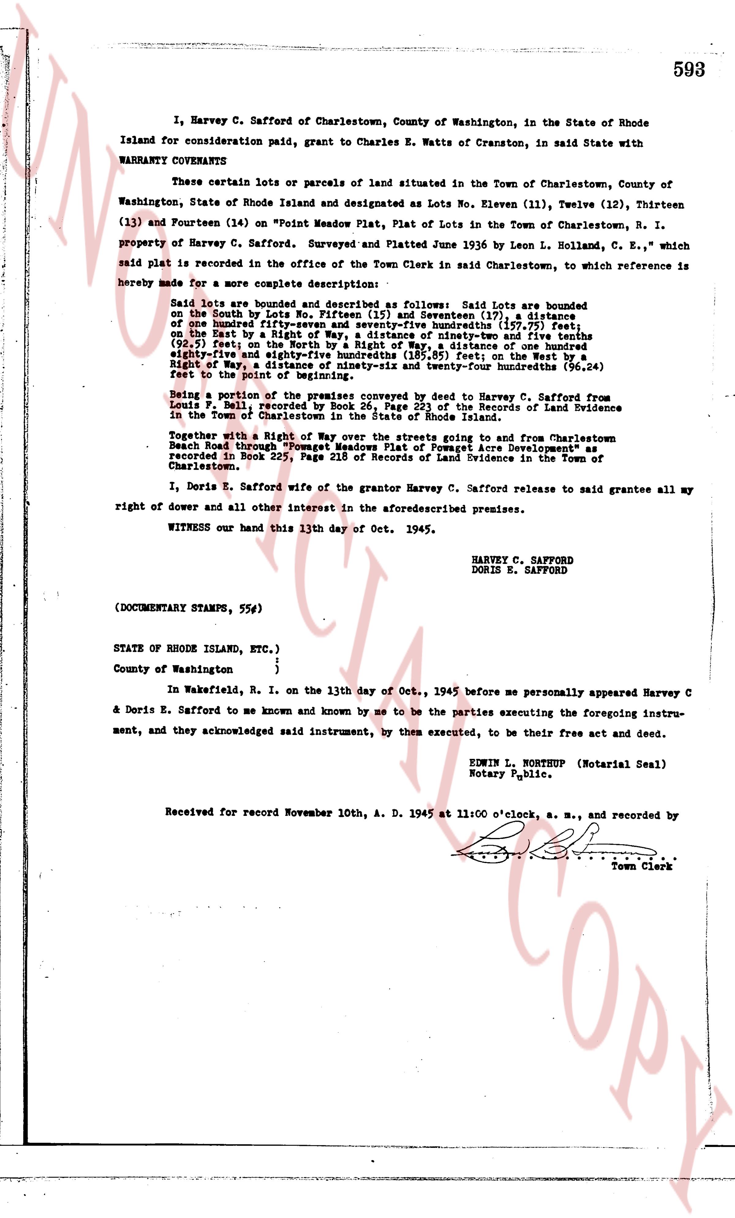
page 1

deed_walker_v1.9_2026-10-10 · the index is the town's own (i2l.uslandrecords.com); transcripts, chains and the assessor's cards are the Perry Machine's reading of it. Where the record we hold runs out, the page says so.