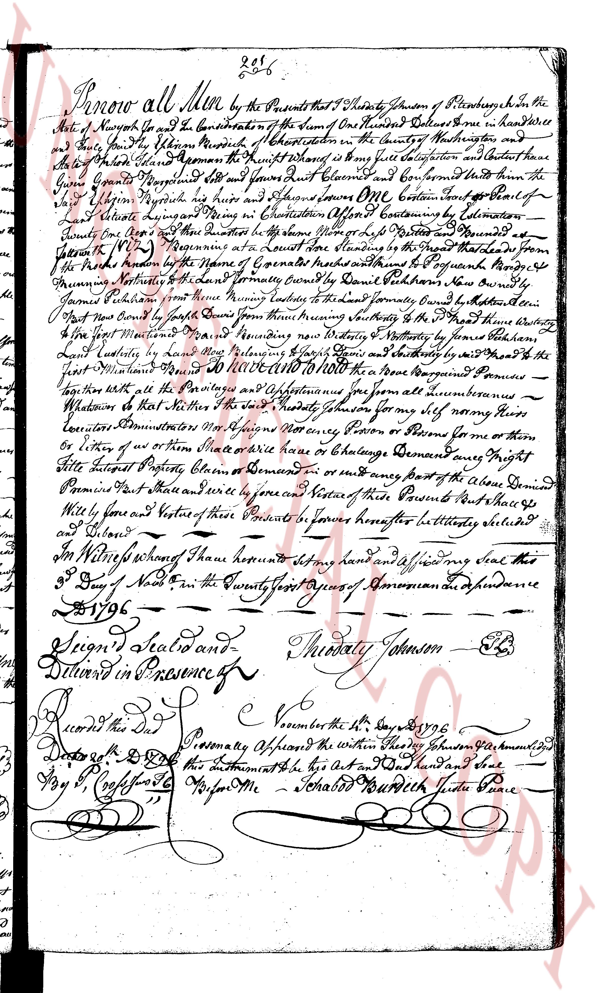
The instrument's own words
page 1
206
Know all Men by these Presents that I Theodory Johnson of Pittsburg in the
State of New York do grant and convey for the Consideration of the Sum of One Hundred Dollars Good and in hand Will
and truly paid by me William Murdoch of Chapman station in the County of Washington and
to his Heirs and Assigns Forever the Premises Which are as follows viz a certain piece of land
lying in the County of Washington and called Jones Flat Claimed and Confirmed unto the
said William Murdoch by his heirs and Assigns One come containing by Calculation
110 Acres lying and being on the North side of the Ohio River of the said Claim and bounded
Easterly by the line of [illegible] and bounded
Southerly by the [illegible] boundaries of a certain survey made by David Patterson from our boundary
James Patterson from the same running Easterly to the said boundary Frome Easterly to the line
of Nat Nat New Com by the south side of the same from there meandering Southeasterly to the [illegible] that there twenty
five feet Mountain [illegible] and meandering now Easterly and Westerly to the survey by Isaac Patterson
Land boundary and run meandering Northwesterly to the same boundary and Easterly by the said line to the
first Mountain [illegible] and thence to the place from which the said boundary first commenced
together with all the Privileges and Appurtenances thereunto from all nuisances
Whatsoever to the said William Murdoch Johnson for my self namely heirs
Executors Administrators Mrs Assigns Not urgency Person or Persons derive for some or
by virtue of any other instrument Write or lease or Exchange Demand any Right
Title Interest Property Option Claim or Demand in or any part of the aforesaid Demised
Premises Fast shall and will by force and Virtue of these Presents and Vesture of these Presents and the said
will by force and Vesture of these Presents forever hereafter let settled placed
and Bound
In Witness whereof I have hereunto set my hand and affixed my Seal this
3 Day of Novr in the Twenty first year of our Dominion and Independence
1796
Signed Sealed and Theodory Johnson [Seal]
Delivered in Presence of
[Signature] [Signature]
Recorded this Day
the November the 3rd 1796
Dated 4th D. D. Personally appeared the within Theodory Johnson Acknowledged
by P. C. [illegible] to be his Act and Seal and paid one dollar
Wife Me Schabbed Murdoch Judge Peace
The page as recorded