The Deed Walker · From Ninigret · Charlestown, Rhode Island land evidence, 1738 to today
Trail: 1764@30/548 › 106@27/633

5/11/1939 · TAX COLLECTOR'S DEED · book 27 page 633 doc 106@27/633

From DAVISON GEORGE A life
To LINK CHARLES J, LINK DOROTHY T
Premises Lot 17 on Quonochontaug Plat (East Beach Road, Quonochontaug East Beach, Charlestown Pond, Charlestown)
Index description AP 4 LOT 36

Back — where this land came from

deed Leon L. Colman, R. E.
“conveyed in 1930 by Leon L. Colman, R. E.”
no book and page cited; the source is named, not recorded here
read by: gemma
deed The Quony Realty Corporation
“deed from The Quony Realty Corporation to this Grantor dated January 10, 1930”
no book and page cited; the source is named, not recorded here
read by: gemma

The grantor's earlier acquisitions, by name — the man, not necessarily this land

◀ 1927 · DEED · VARS NELSON B; VARS CAMILLA E → DAVISON GEORGE · book 23 p 78

Forward — where this land went

The grantee's later conveyances, by name — the man, not necessarily this land; the one that cites this deed as its source is the land

▶ 1939 · MORTGAGE ASSIGNMENT · LINK CHARLES J; LINK DOROTHY T; ARNOLD THOMAS L; WASHINGTON TRUST COMP → ARNOLD LYNDON; ARNOLD THOMAS L; ARNOLD THOMAS L DECEASED; WASHINGTON T · book 28 p 103
▶ 1939 · MORTGAGE DISCHARGE · LINK CHARLES J; LINK DOROTHY T → RINKER DORETTA; RINKER JOHN R · book 27 p 263
▶ 1940 · DEED · LINK CHARLES J; LINK DOROTHY T → CULLINAN ALICE J · book 28 p 197
▶ 1944 · DEED · LINK CHARLES J; LINK DOROTHY T → JOHNSON GENEVIEVE; JOHNSON JOHN N · book 29 p 228
▶ 1947 · DEED · LINK CHARLES J; LINK DOROTHY T → LINK RUTH CONSTANCE; LINK CHARLES W; HIGGINS SAMUEL M · book 30 p 548
▶ 1949 · DEED · LINK CHARLES J; LINK DOROTHY T → MOLLER MARILYN R; MOLLER THEODORE W JR · book 31 p 464
▶ 1949 · DEED · LINK CHARLES J; LINK DOROTHY T → GODDEN GLENN F; GODDEN MILDRED L · book 31 p 634
▶ 1955 · DEED · LINK CHARLES J; LINK DOROTHY T → MOLLER ROSE J; MOLLER THEODORE W · book 35 p 225
▶ 1955 · DEED · LINK CHARLES J; LINK DOROTHY T → GODDEN GLENN F; GODDEN MILDRED L · book 35 p 226
▶ 1959 · AGREEMENT · LINK CHARLES J; LINK DOROTHY T → NARRAGANSETT ELECTRIC COMPANY · book 36 p 519
▶ 1960 · DEED · LINK CHARLES J; LINK DOROTHY T → HARTFORD SURF FISHING CLUB INC · book 37 p 245
▶ 1962 · DEED · LINK CHARLES J; LINK DOROTHY T → SPEAR ELEANOR · book 38 p 283
▶ 1966 · DEED · LINK CHARLES J; LINK DOROTHY T → RICE DUDLEY T; RICE HAZEL B · book 41 p 107
▶ 1966 · DEED · LINK CHARLES J; LINK DOROTHY T → DAY MARJORY C; DAY ROBERT S · book 41 p 285
▶ 1972 · MORTGAGE · GODDEN GLENN F; GODDEN MILDRED L; LINK CHARLES J; LINK DOROTHY T; RAND → PROSSER RUFUS K · book 47 p 6

The instrument's own words

page 1 · read by Gemma vision
687 I, Gertrude L. Strayer, unmarried, of the City of Cranston, County of Providence, State of Rhode Island for consideration paid, grant to The Quony Realty Corporation, a corporation duly incorporated and created under the laws of the State of Rhode Island and having a place of business in the City of Providence, County of Providence aforesaid with WARRANTY COVENANTS That certain real estate situated in Charlestown, County of Washington in the State of Rhode Island, and described as follows: A certain tract of land consisting of a lot of land situated on the easterly side of the East Beach Road, so called, or Quonochontaug East Beach in the Town of Charlestown aforesaid, and bounded and described as follows, to wit: Beginning at a point on the easterly side of the East Beach Road, said road forming the westerly line of other land of the grantor and the northeast corner of the premises hereby conveyed, thence running easterly Two Hundred eighty-eight and eight-tenths feet (288.8) to the easterly line of other land of the grantor, thence running southerly One Hundred (100) feet, more or less, to the southeast corner of the premises hereby conveyed; thence running westerly Two Hundred eighty-eight and eighty-eight hundredths feet (288.88) to the East Beach Road aforesaid; thence running northerly One Hundred (100) feet to the place of beginning, the westerly line of the premises hereby conveyed, being the highway, or northerly lot of other land of the grantor, eased by land of Henry W. Rose as authorized by the state of Rhode Island. Meaning and intending to convey Lot No. 17 as shown and delineated on a certain plan or plat entitled, "Quonochontaug Plat, Charlestown, Rhode Island, owned by The Quony Realty Corporation" and containing such equal 50 foot lots as were conveyed in 1930 by Leon L. Colman, R. E., said plat being duly recorded in the Land Evidence Records of said Town of Charlestown. In addition to the above described premises said grantor, its successors and assigns is also granted the right of way to Charlestown Pond all as expressed in a certain deed from The Quony Realty Corporation to this Grantor dated January 10, 1930 and duly recorded in the Land Evidence Records of said Charlestown. Consideration less than $100, no stamp necessary. WITNESS my hand this 11th day of May 1939 GERTRUDE L. STRAYER (SEAL) STATE OF RHODE ISLAND) County of Providence } In Providence, on the 11th day of May, 1939 before me personally appeared Gertrude L. Strayer to me known and known by me to be the party executing the foregoing instrument, and she acknowledged said instrument, by her executed, to be her free act and deed. DARIUS M. DICKERSON (Notarial Seal) Notary Public Received for record May 27th, A. D. 1939 at 9:05 o'clock, a. m., and recorded by [Signature] Town Clerk

The page as recorded
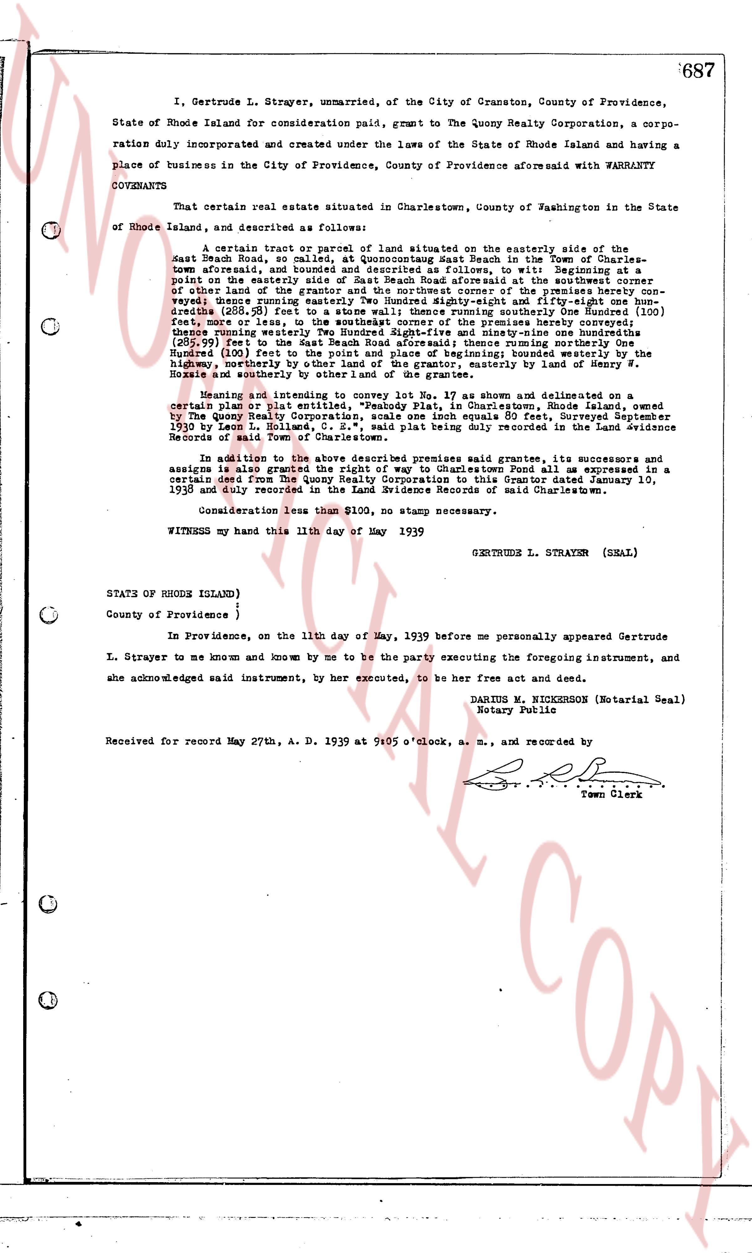
page 1

deed_walker_v1.9_2026-10-10 · the index is the town's own (i2l.uslandrecords.com); transcripts, chains and the assessor's cards are the Perry Machine's reading of it. Where the record we hold runs out, the page says so.