The Deed Walker · From Ninigret · Charlestown, Rhode Island land evidence, 1738 to today
Trail: 6004 › 18@29/180 › 104@28/274

7/24/1940 · TAX COLLECTOR'S DEED · book 28 page 274 doc 104@28/274

From DUNN GRETTA K
To CHARLESTOWN TOWN OF life, CROSS WILLIAM D life
Premises none · tract on Westerly side of Providence highway (Charlestown, Providence highway, Ross Hill)
Index description AP 5 LOT 8

Back — where this land came from

This instrument states no source of title that we have read yet.

The grantor's earlier acquisitions, by name — the man, not necessarily this land

◀ 1925 · DEED · DUNN FRANK M → DUNN GRETTA K · book 21 p 499

Forward — where this land went

Follow forward ▶ 1949 · DEED · CHARLESTOWN TOWN OF; DUNN GRETTA K → GRINNELL LEON; SQUIER LEONARD K · book 31 p 664
“Land Evidence : Book Page 28 274 Gretta K. Dunn.”
cites this instrument as its source · read by gemma

The grantee's later conveyances, by name — the man, not necessarily this land; the one that cites this deed as its source is the land

▶ 1940 · DEED · CROSS CELIA M; CROSS WILLIAM D → WRIGHT FLORENCE A; WRIGHT HIRAM L · book 28 p 246
▶ 1940 · DEED · CROSS CELIA M; CROSS WILLIAM D; BARBER EMMA E; CROSS WILLIAM D DECEASE → WRIGHT FLORENCE A; WRIGHT HIRAM L · book 28 p 247
▶ 1941 · TAX SALE RETURN · CROSS WILLIAM D; DAVID JOSEPH B; GILMARTIN EUGENE R; CENTRAL TOOL CO; → CHARLESTOWN TOWN OF; LASKEY HOWARD G; TIMPERLEY J WILLIAM; TIMPERLEY R · book 28 p 474
▶ 1942 · TAX SALE RETURN · CLARK CLARENCE L; CROSS WILLIAM D; CHARLESTOWN TOWN OF; MINER ETHEL; T → GREEN HATTIE; CHARLESTOWN TOWN OF; CROSS WILLIAM D; GREEN ERNEST · book 28 p 693
▶ 1944 · DEED · CROSS CELIA M; CROSS WILLIAM D; BARBER EMMA E; CROSS GEORGE W DECEASED → BROWN ALBERT E · book 29 p 180
▶ 1944 · DEED · CROSS CELIA M; CROSS WILLIAM D → BOOTHMAN ERNEST R · book 29 p 271
▶ 1944 · TAX SALE RETURN · CHARLESTOWN TOWN OF; CLARKE EDWARD M; CROSS CELIA M; CROSS WILLIAM D; → · book 29 p 285
▶ 1944 · DEED · CROSS CELIA M; CROSS WILLIAM D → WALKER ALICE L · book 29 p 296
▶ 1945 · DEED · CROSS CELIA M; CROSS WILLIAM D → GRIMES EMILY R; MCVAY ELLEN E; BROOKS ELIZABETH J · book 29 p 424
▶ 1945 · DEED · CROSS CELIA M; CROSS WILLIAM D → CLARKE EDWARD M · book 29 p 519
▶ 1946 · DEED · CROSS CELIA M; CROSS WILLIAM D → WOODMANCY GLADYS M; WOODMANCY WILLIAM N · book 30 p 259
▶ 1948 · DEED · CROSS CELIA M; CROSS WILLIAM D → LEWIS GEORGE H · book 30 p 678
▶ 1949 · DEED · CROSS CELIA M; CROSS WILLIAM D → BERRY GEORGE M; BERRY JOHANNA · book 31 p 594
▶ 1950 · DEED · CROSS CELIA M; CROSS WILLIAM D → DEAN FORREST E; DEAN THELMA L · book 32 p 84
▶ 1955 · DEED · CROSS CELIA M; CROSS WILLIAM D → WOOLLEY FREDERICK; WOOLLEY MARY L · book 34 p 493
▶ 1960 · DEED · CROSS CELIA M; CROSS WILLIAM D → FORAN FRANCIS L; FORAN LUCIENNE A · book 37 p 202

The instrument's own words

page 1 · read by Gemma vision
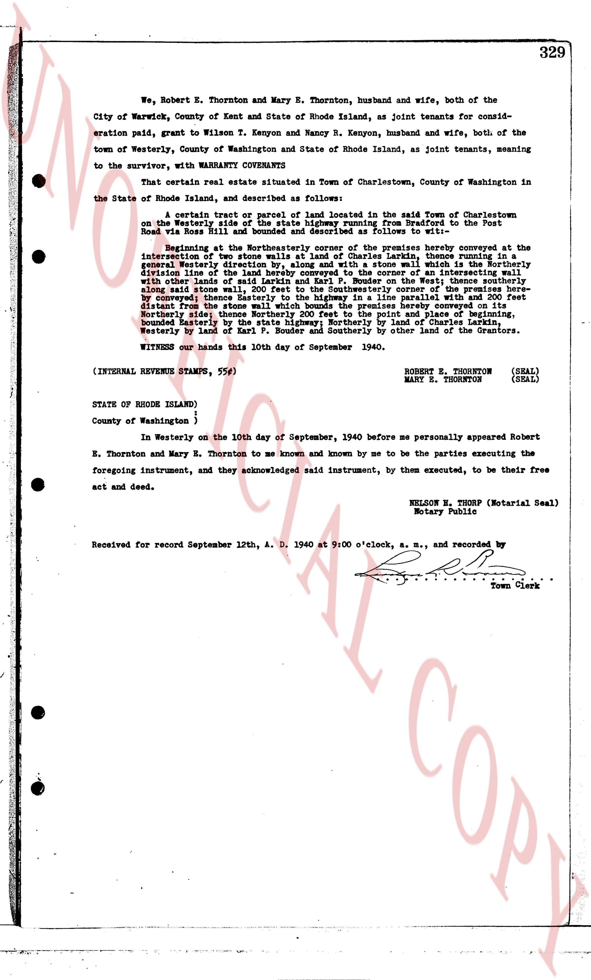
329 We, Robert E. Thornton and Mary E. Thornton, husband and wife, both of the City of Warwick, County of Kent and State of Rhode Island, as joint tenants for consideration paid, grant to Wilson T. Kenyon and Nancy R. Kenyon, husband and wife, both of the town of Westerly, County of Washington and State of Rhode Island, as joint tenants, meaning to the survivor, with WARRANTY COVENANTS That certain real estate situated in Town of Charlestown, County of Washington in the State of Rhode Island, and described as follows: A certain tract or parcel of land located in the said Town of Charlestown on the Westerly side of the Providence highway, from the Post Road to the Post Road via Ross Hill and bounded and described as follows to wit:— Beginning at the Northeasterly corner of the premises hereby conveyed at the intersection of two stone walls, land of Charles Larkins, thence running in a south easterly direction with a stone wall, along a stone wall with the land of the south easterly division line of the land hereby conveyed to the corner of an intersecting wall with other land of Charles Larkins, thence running South westerly with a stone wall along said stone wall, 200 feet to the Southwestern corner of the premises hereby conveyed thence Easterly to the highway in a line parallel with and 200 feet distant from the stone wall, then running North easterly with the highway to the North easterly side; thence Northerly 200 feet to the point and place of beginning, bounded Easterly by the highway, Northerly by land of George S. Larkins, South westerly by land of Karl P. Bouder and Southerly by other land of the Grantors. WITNESS our hands this 10th day of September 1940. (INTERNAL REVENUE STAMPS, 55¢) ROBERT E. THORNTON (SEAL) MARY E. THORNTON (SEAL) STATE OF RHODE ISLAND) County of Washington } In Westerly on the 10th day of September, 1940 before me personally appeared Robert E. Thornton and Mary E. Thornton to me known and known by me to be the parties executing the foregoing instrument, and they acknowledged said instrument, by them executed, to be their free act and deed. NELSON E. THORP (Notarial Seal) Notary Public Received for record September 12th, A. D. 1940 at 9:00 o'clock, a. m., and recorded by [?] Town Clerk

The page as recorded
page 1

deed_walker_v1.9_2026-10-10 · the index is the town's own (i2l.uslandrecords.com); transcripts, chains and the assessor's cards are the Perry Machine's reading of it. Where the record we hold runs out, the page says so.