The instrument's own words
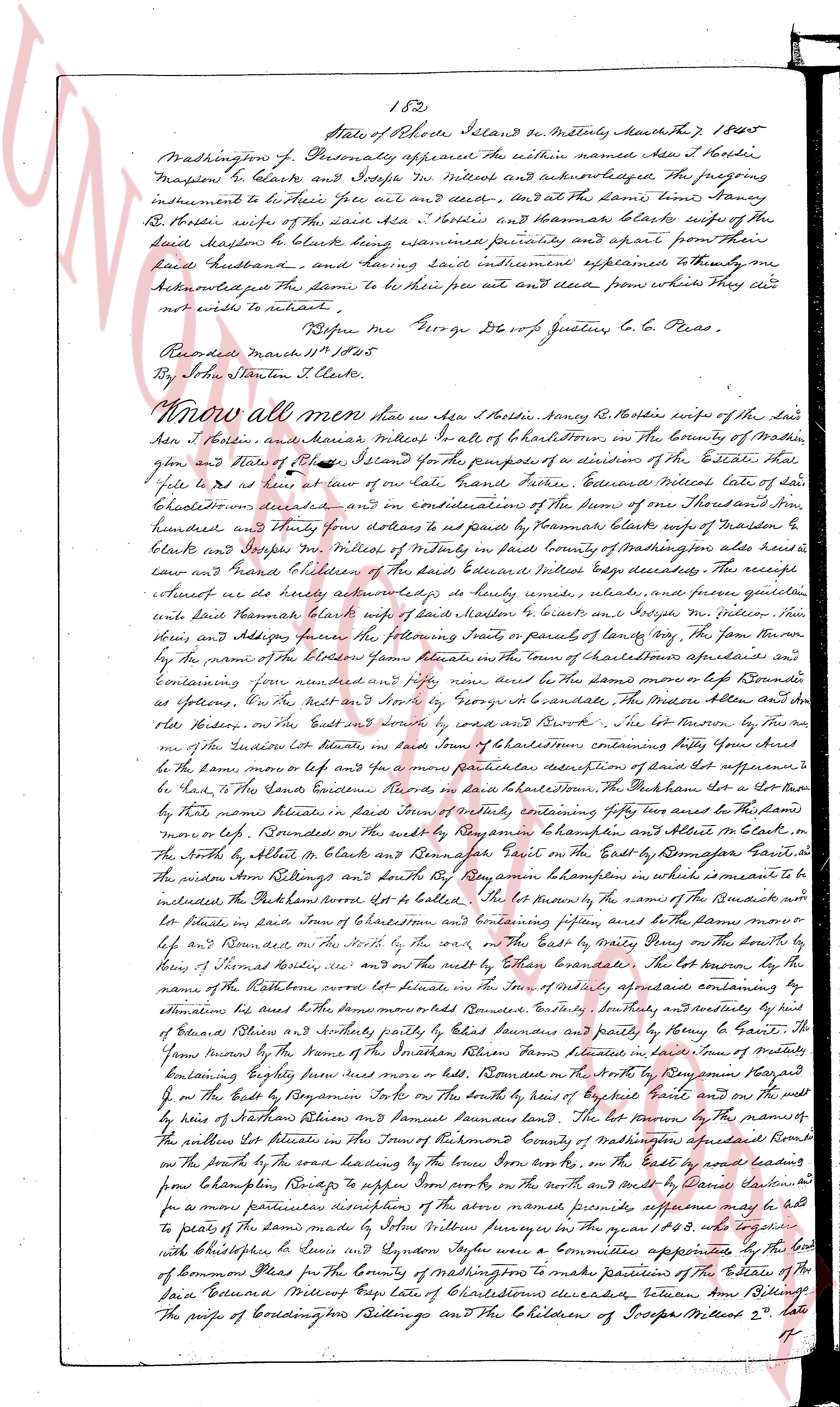
page 1
152
State of Rhode Island ss. In the town of North Kingstown March the 7th, 1805
Washington Co. Personally appeared the within named Ann S. Hardin
Mason & clerks and Joseph W. Miller and acknowledged, the foregoing
instrument to be Theirs free act and deed, and at the same time, came Nancy
R. B. Hardin wife of the said Ann S. Hardin and Thomas Blake wife of the
said Mason & clerks having upon examination propriety and apart from their
said Husband and Wife having said instrument exemplified to them they ac
knowledged the same to be their free act and deed from which they are
not wish to retract.
Before me George De Vore Justice of the Peace.
Recorded March 11th 1805
By John Stanton Clks.
Know all men that I Ann S. Hardin & Nancy R. B. Hardin wife of the said
Ann S. Hardin and Thomas Blake wife of the said Thomas Blake in the County of Washington
state and State of Rhode Island for the purpose of a division of the Estate that
pile to be as law at one of our late Grand Father Edward Blake late of said
North Kingstown deceased and in consideration of the Sum of one Thousand And
hundred and thirty four sterling to be paid by Thomas Blake wife of Mason &
clarks and Joseph W. Miller attorney at law in the County of Washington also a
law and citizen of the said Edward Blake late deceased. This receipt
attest we do hereby acknowledge to be fully and ample, legal and general quit
claim and deed from Husband & Wife’s hand to Thomas Blake and Joseph W. Miller then
their Attorney further the following realts in part of parcels of land lying in the town
by the name of the Plot of Thomas Blake in the town of Charlestown aforesaid and
containing four hundred and fifty acres more or less the same more or less bounded
as follows On the North by the land of George De Vore justice of the Peace Mason and
old fence On the South by deed and survey and bound by C. S. the lot known as by the
name of the Southern lot situate in said town of Charlestown containing fifty four acres
be the same more or less and a few more particular description of said lot sufficient to
lead to the said Land’s Evidence more in said Charlestown. The particular lot a few lots
by that name situate in said town of Charlestown containing fifty two acres to the said
more or less Bounded on the North by Raymond to Benjamin Campen and Albert Blake in
the North by William & Albert Blake and Benjamin De Vore on the East by Benjamin De Vore
the widow Ben Billings and John R. Raymond Benjamin Campen in which is measure to be
included the Pulveron lot’s lot to be settled. The lot known by the name of the Bound lot
or Plot lot situate in said town of Charlestown and containing fifteen acres to the plain more
or less on the South by the lot of the said on the East by Mary Day on the North by
lee and Raymond on the North of the said and on the East by Ethan Bonaventure the lot known
by the name of Natural cove lot situate in the town of Charlestown aforesaid containing by
estimation four hundred acres bounded North by David Bonaventure and partly by David and
of Edward Blake and partly by David Bonaventure and partly by Henry De Vore the
farrow known by the name of the Southern farrow known as the land in one of many of
containing eighty three acres more or less Bounded on the North by Raymond and Raymond
on the East by the Boyton map on the North of the South by David Blake and on the West
by lee of Nathan Atkins & Benjamin De Vore bounded the lot known by the name of the
Pulveron lot situate in the town of Providence County of Washington aforesaid containing
the Pulveron lot situate in the town of Providence County of Washington aforesaid containing
on the North by the road leading to the town from the town on the East by David Bonaventure
from Campen Billings’s upper home on the West and on the South by David Bonaventure
as per more particular description drawing more marked premises aforesaid as per the
per to the parcels of the said land by John Miller survey in the year 1803 and together
with Christopher S. and Sydney Syson were a Committee appointed by the Court of
Common Pleas for the County of Washington to make partition of the Estate of the
said Edward Blake of Charlestown deceased between Ann Billings
The purse of Corrington Billings and the Children of Joseph Miller 2nd late
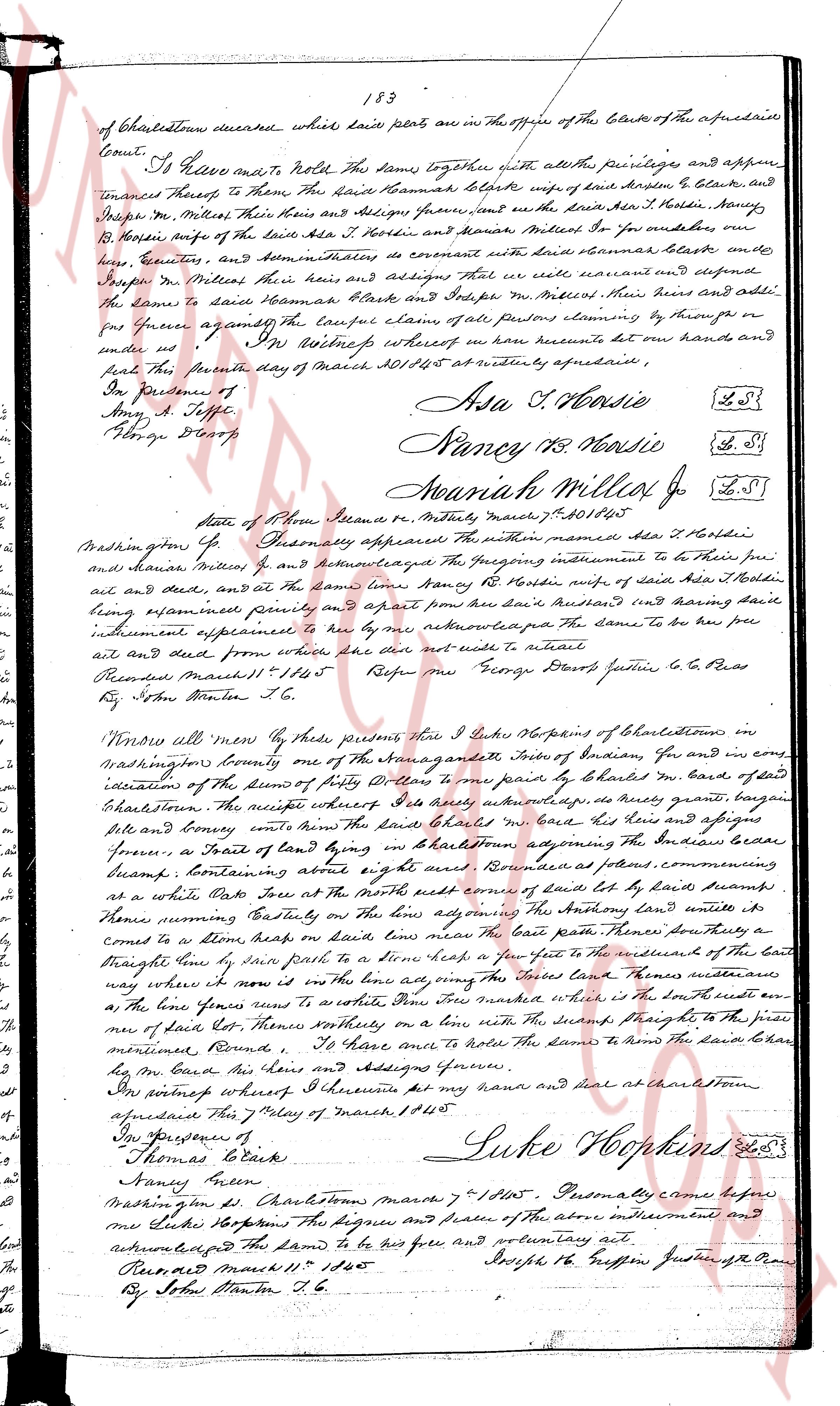
page 2
183
of Charlestown deceased whose land parts are in the Office of the Clerk of the aforesaid
Court.
I have made and hold this land together with all the privileges and appurten
ances thereof, to them the said Hannah Blakes wife of said Joseph Blakes, and
Joseph Mr. Milles their heirs and assigns forever, and in the said Joseph Hardy
Jr. Milles their heirs and assigns forever, and Hannah Milles Jr. for ourselves our
heirs executors and administrators covenant to warrant and defend said Hannah Blakes and
Joseph Mr. Milles their heirs and assigns that we will warrant and defend the
lands to the said Hannah Blakes and Joseph Mr. Milles their heirs and assigns
forever against any and all persons claiming the same by through or
under us. In witness whereof we have set our hands and seal to this
deed the twenty first day of March AD 1805 at Notary aforesaid.
In Presence of
Amy A. Topp
George Dexter
Asa T. Bossie L.S.
Nancy T. Bossie L.S.
Hannah Milles Jr L.S.
State of Rhode Island Providence et May 17th 1805
Washington Co.
Washington Co.
Personally appeared within named Asa T. Bossie
and Hannah Milles Jr and acknowledged the foregoing instrument to be their free
act deed and seal and at the same time Hannah Hardy Jr. wife of said Asa T. Bossie
being examined privately and apart from her said Husband and declaring herself
instrument explained to her by her representative the same to be her free
act and deed seal from where she did write and seal it.
Recorded March 11th 1805 Refer me George Bossie Father to L.C. Bossie
By John Danter T.C.
Vendue all more over by these presents since I Luke Hopkins of Charlestown in
Washington County one of the emancipated Indians of Indian Country and in my name
indication of the deeds of Henry Williams to me paid by Charles Mr. Blake of said
Charlestown the receipts whereof I do hereby acknowledge a piece of land commanding
a white hole and convey unto the said Charles Mr. Blake his heirs and assigns forever
a tract of land lying in Charlestown adjoining the Indian boundary border
forever a tract of land lying in Charlestown adjoining the Indian boundary border
forever a tract of land lying in Charlestown adjoining the Indian boundary border
forever containing and about 4 acres bounded as follows commanding
a white hole some bounds on the North with some bounds of land set by land bounded
on the West with some bounds on the North with some adjoining the Anson land until it
touches running westerly on the line bounds the East path some there they
come to a stone heap on said line bounds some line bounds there they
straight line to some rock path to a stone bound few feet to the west of the marshes of the
way where no way more is on the line and ring the said land marks whereas
on the line runs a stone wall to a white oak tree marked where it is the southeast corner
of the line some feet there some witnesses on a line until the swamp straight to the pine
most mentioned bounds I do have me and hold the same to the said Charles Blake
by me my heirs the heirs and assigns forever.
In witness whereof I do execute set my name and seal at Charlestown
on this 27 day of March AD 1805
In Presence of
Thomas Blake
Nancy Allen
Luke Hopkins L.S.
Personally came before
me Luke Hopkins the signer and seal of the above instrument and
acknowledged the same to be his free and voluntary act.
Recorded March 11th 1805 Joseph T.C. Jefferson Justice of the Peace
By John Danter T.C.
The page as recorded