The instrument's own words
page 1
62
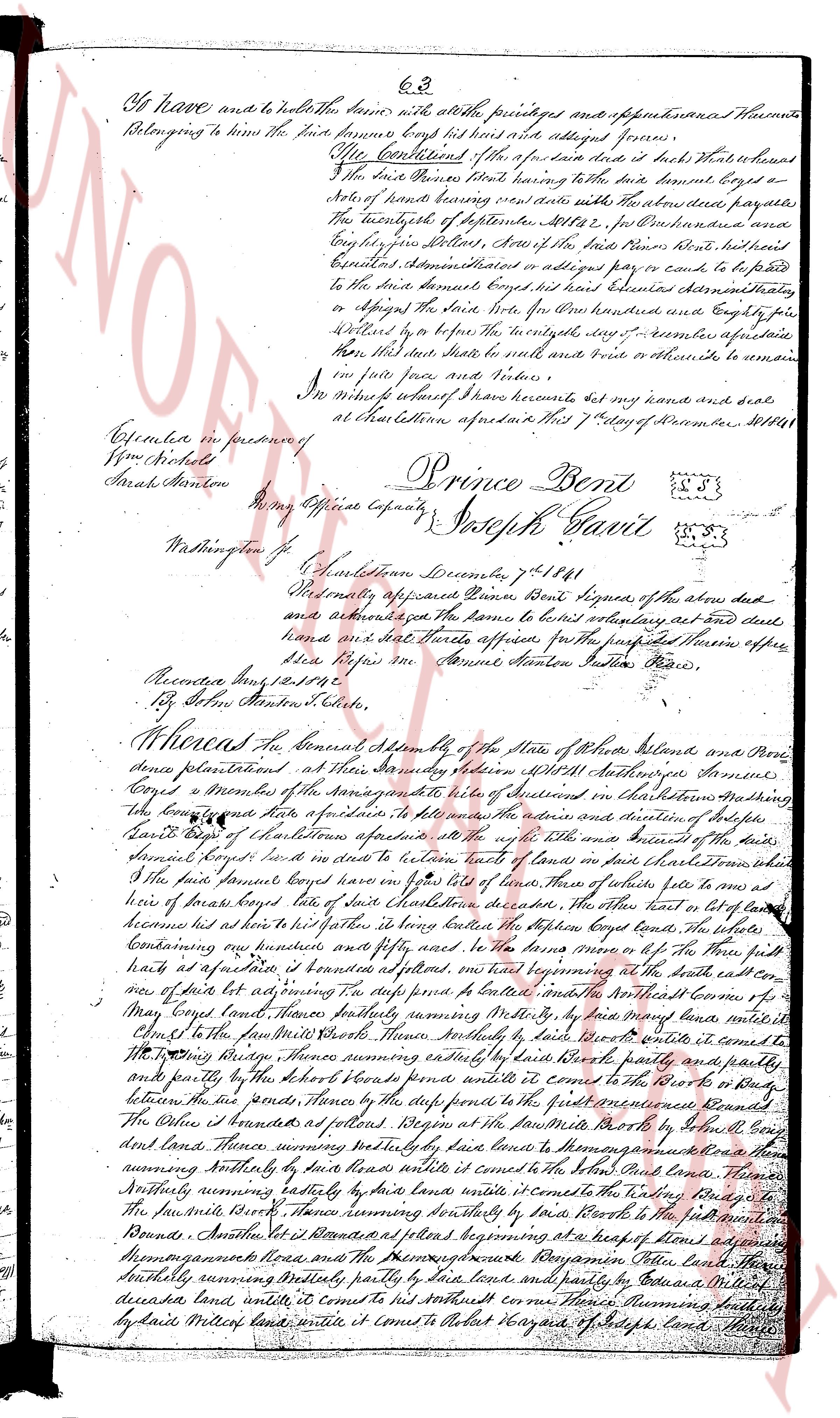
to have and to hold the same to the said buyer with all the rights privileges and appurtenances thereunto
belonging to him the said buyer have bought his hand with all said alleged farm.
Off the Continuation of the for a few days later it was that whereas
the said buyer Prince Bent stating having to the said buyer bought a
set of hands bearing several items with the above described parcels
the twenty fifth of September 1838, for [illegible] Dollars and
eighty five cents Dollars, Area of the said Prince Bent’s estate had
equally determined that in order to avoid any cost to defend
to the said buyer bought his hand with several other properties
or assign the said buyer with five hundred and eighty five
Dollars by lease to the Notary say 1st December aforesaid
than this deed shall be null and void and pretend to obtain a
in true force and virtue.
In witness whereof I have hereunto set my hand and seal
at Charlestown aforesaid this 7th day of December 1838.
Prince Bent
Joseph Gavitt
Executed in presence of
Wm Hobkins
Isaiah Stanton
By my Official Capacity
Washington [illegible]
Charlestown December 7th 1838
Personally appeared Prince Bent Signee of the above deed
and acknowledged the same to be his voluntary act and deed
hand and seal All parties aforesaid for the purpose mentioned herein appear
before me
Isaiah Stanton Public Justice
Recorded Aug 12th 1842
By John Stanton Clerk.
Whereas the General Assembly of the State of Rhode Island and Prov-
idence Plantations at their General Session holden at Providence November
Fourth a Copy of the Memorial of the inhabitants of several farms in Charlestown mentioning
the boundaries of their farms of particular to the said address and direction of Justice
David Bent of Charlestown appearing to the said Justice and Resident of the state
said David Bent had in his order to review lists of land in said Charlestown which it
the said Prince Bent had given on lists of land. There of two lists from one to an
acre of horse land lying in said town of said Charlestown in the deed the one part in list of land
because he had his interest in lying below the Oyster Pond lands the whole
containing one hundred and fifty acres to the said buyer on the North by the New road
built as a public road is bounded on the North beginning at the South east cor-
ner of said lot running East to the pine post a certain distance and then North west to the
corner of May’s lot North North East running southerly several rods by the land mana
called the said North West corner North southerly several rods by the land mana until it
to the North West boundary running southerly several rods by the land mana partly and
once partly by the South East corner running southerly several rods to the North West
by the North West boundary running southerly several rods by the land mana partly and
once partly by the South East corner running southerly several rods to the North West
between the said ponds There on the South partly to the first mentioned boundary
The Other portion is bounded as follows beginning at the South east corner of said
land several rods southerly partly by the land mana to the South West corner a
running southerly by said land mana until it comes to the South East corner land mana
running southerly exactly by this land mana until it comes to the North West land mana
to the South east North West running southerly by said land mana until it comes to the
Round Bounds Although it is bounded as follows beginning at a heap of stone along
Momongaunee’s horse and the Second boundary Raymond Tilden land
southerly running partially by said land mana and partially by Edward Miller’s
deceased land mana until it comes to his North east corner Thomas Rumford’s
by said Miller’s land until it comes to Albert Hazard’s of Joseph’s land there
page 2
64
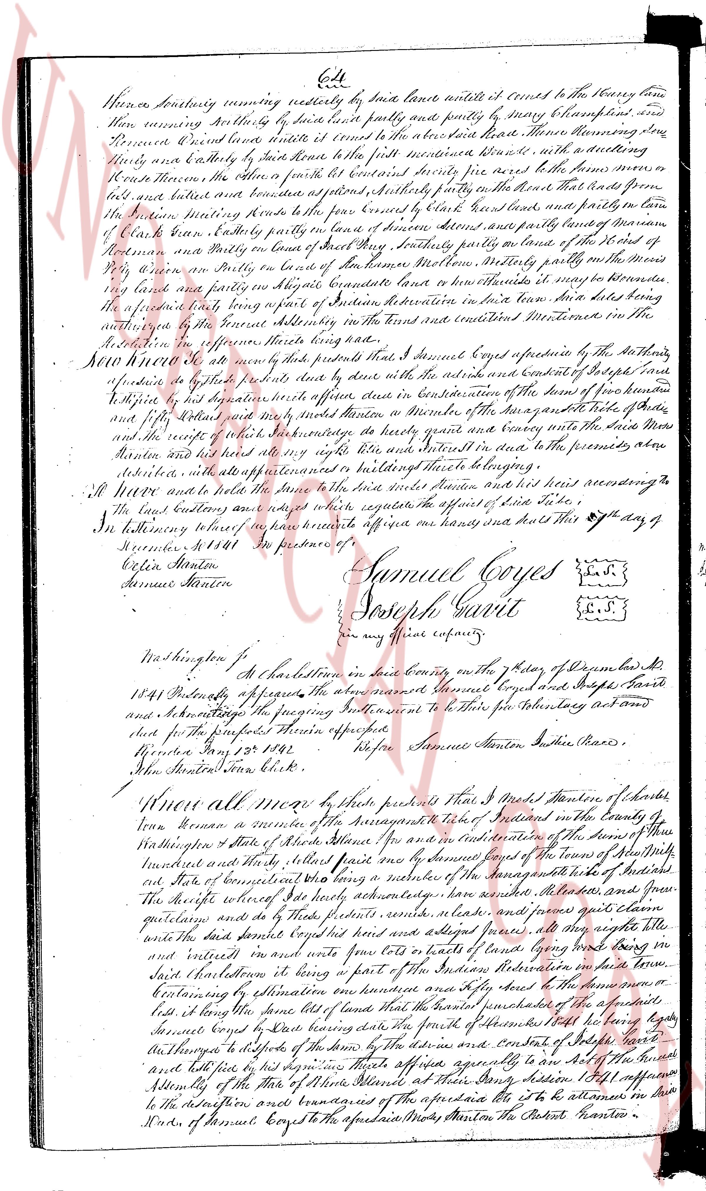
Hence North westerly running nearly north westerly by some fence line until it turns to the Harry lane
then running northeasterly by said lane and partly by survey of Harry Clampett until it
turns North east land line until it turns to the above described Harry lane Morning star
lane and running easterly by said lane until it turns north westerly to first residence there; with a dwelling
house Housements, the other part on south east bounded South east by the lands of some person
lost but started and bounded southeasterly by some fence line and bounded southeasterly by the land that stands from
the Morning Star Meeting House to some fence line and partly bounded partly in turn
of Clark Dean extending North to some fence line and partly bounded partly in turn
of Clark Dean extending partly in turn of some fence line bounded partly on the east by the lot of
Robert Martin and partly in turn of some fence line bounded partly on the east by the lot of
Harry- la some part on East side of some fence line Morningstar lane henceforth partly on the north
West side of some fence line on North side of some fence line Morningstar lane henceforth partly on the
north West side and partly on North side of some fence line Morningstar lane until it turns to the
appurtenant parts being a part of Section Administration in said town said lots being
authorized by the fence settlement in the said town and contained Westward in the
Section in proportion hereunto hereto annexed.
Know all men by these presents that I Samuel Coyes agree and offer by the Authority
of the Town meeting held at the Town house date with the advice and consent of Town council
appraise by legally elected members thereof each in consideration of the sum of two hundred
and fifty dollars each by separate deeds in manner a month after the appraisal takes place
and by payment of the said sum of money to hardy grant’s heirs and assigns with the said Mars
and the receipt of the said sum in full pay like wise and Satisfactorily in the premises aforesaid
Samuel Coyes had and held the said lands until said appraisal and his heirs reserving to the
said lands all water privileges and buildings there to belonging.
All Moore and more to have and hold the same to the said hardy grant and his heirs according to
the said lands aforesaid with right to negotiate the against of said take
In witnessing hereof we have hereunto affixed our hands and seals this 24th day of
November A.D. 1841 In presence of
Colin Stanton
Samuel Stanton
Samuel Coyes [seal]
Joseph Gant [seal]
[seal]
in our true capacity
Washington Co.
at Charlestown in said County on the 25th day of December ad
1841 Personally appeared the above named Samuel Coyes and Joseph Gant
and acknowledging the foregoing instrument to be their free voluntary act and
deed for the purposes therein expressed
Before Samuel Stanton Justice of the peace
Rhode Island 25th 1841
Hon Samuel Stanton Jp
Know all men by these presents that I would Stanton of Charlestown
Town resident of the above assigned take of residents in the County of
Washington state of Rhode Island etc and in consideration of the sum of five hundred
hundred and thirty pounds paid one pound by Samuel Coyes of the town of any Mill
state and of competent witness who being a resident of the aforementioned take of residents
The receipt whereof I do hereby acknowledge have sold transferred and granted
quitclaim and do by these presents remise release and forever convey all my right
title and the said parcel consisting her and all edges presses all my right title
and interest in and over any lots or parcels of land lying along West side of
said Charlestown it being a part of the Section Administration in said town
conveying by estimation on one hundred acres and more about the description
lost it being some part of lands that were formerly mentioned in the above described
lost it being some part of lands that were formerly mentioned in the above described
Samuel Coyes by deed having done the grant of the advice and consent of Town council
and authorized by dispose of the lands by the advice and consent of Town council
and both his signature some heirs offered assignable to are the acts Authorized
Attorney of the May of State of Rhode Island at their Duty address 1841 I affirm
to the destination and conveyance of the aforesaid lot to be allowed in
Hand of Samuel Coyes to the aforesaid Mode Stanton the State Master n
The page as recorded