The instrument's own words
page 1
13
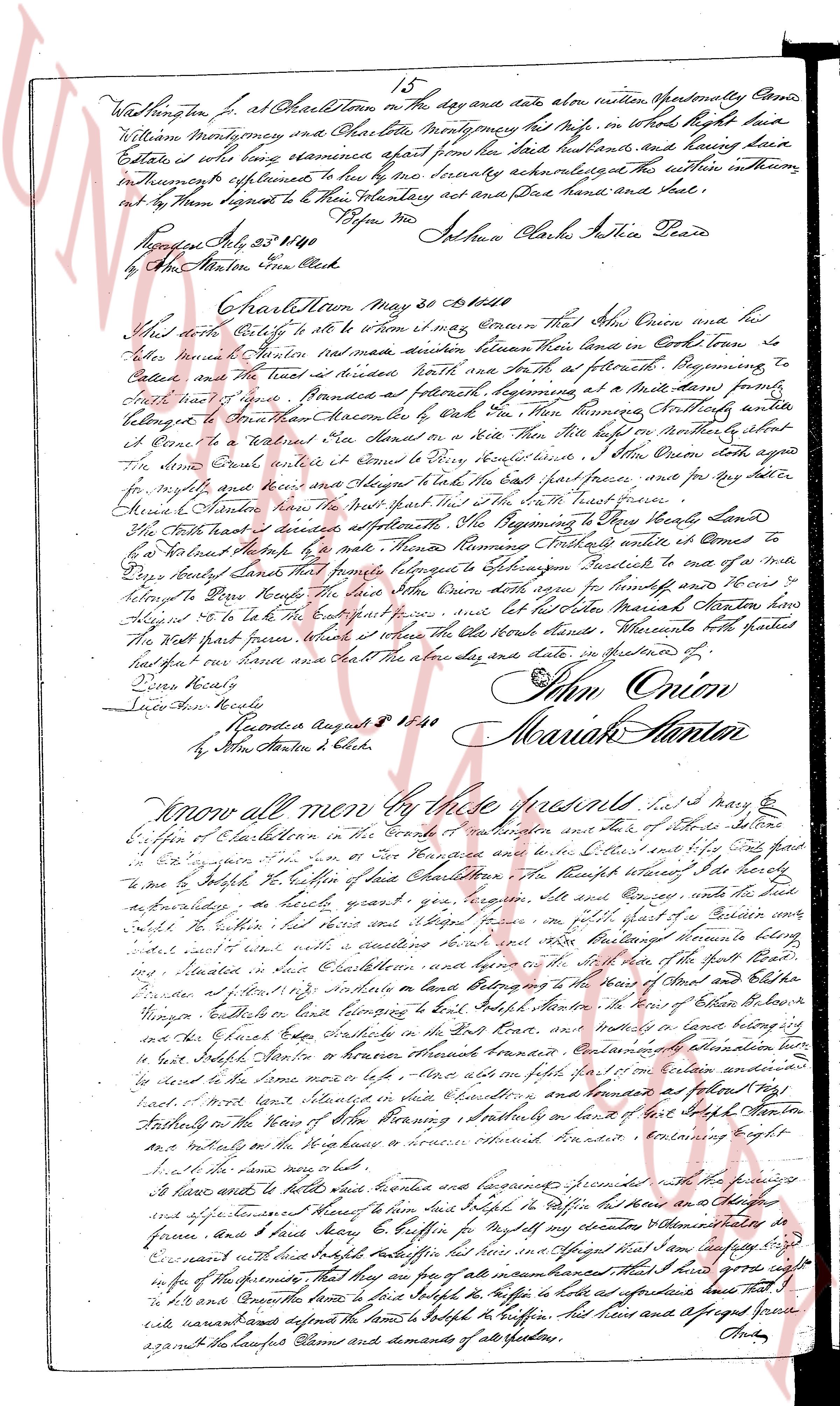
Washington J. at Charlestown on the day and date above written personally Came
William Montgomery and Phebe Otter Montgomery her wife in whom it right true
Estate, is sole long remaine apart from her said husband, and having her Case
In this instrument sufficient, to her she being seriously acknowledged the within instrument
in her Presence signed to her History Attorney act and bind her hand and seal
on this 23rd May 1840
By the Masterton Clerk
Before me
Joshua Clarke Justice Peace
[Signature]
By John Hunter Clerk
Charlestown May 30 1840
This deed Polls to all to whom it may be known That John Onion and his
heirs sells grants conveys delivers between them their land in Corn land to
be called Onion's farm situated within North with a North at fourth Beginning, to
East and South a line straight bounded as follows beginning at a Mark stone from the
Northwest to Great House described by deed dated 18th June knowing Northly and
at Corner to Great House described by deed dated 18th June knowing Northly and
at Corner to a Marked Oak tree standing on a Rite Way then North by North eastly along
the line of John Onion until it Come to a Stone boundary line John Onion agrees also
for rights and privileges and their Heirs align to hold the East part forever, and for any other
Piece of Hunter land, the East part first and the South west piece
The North part described as follows Beginning at the Beginning to North East boundary
by a Marked Ash tree to a Mark knowing Northly Straightly and at Corner to
a Marked Stone boundary line from that point Straightly to Sprague's boundary line to a mark
belonging to Peter Brown the above land John Onion agrees for himself and heirs forever
to Align to be the East part forever, and let the other Marked Marked Hunter how
the North part first, whereas it relates the above land warrants. Whereas both parties
had signed our hands seal the day above date and place in presence of
[Signature]
[Signature]
John Onion
Mariah Hunter
Acknowledged August 11 1840
By John Hunter s. Clerk
Know all men by these presents That I Mary E
Gibson of Charlestown in the County of Kent Rhode Island one of the 2 heirs settlers
in the legacy of John Gibson of New Hampshire now deceased and the 2 other settlers
are my siblings the son of New Hampshire and now reside at Litchfield in the State of Connecticut
to me by Legacy the portion of the land Charlestown in the Township named S. the holds
as followsly, as follows heart year, ten acres and Said land and the heirs align
Said the within, her heirs and align forever in per part of a certain area
said land with a well and a residence house both belonging to the Estate of John Gibson
situated in East Charlestown and lying between and by the side of the Estate of John Gibson
Presided at the north eastly on the land belonging to the Estate of Mary and Esther
Youngen residents of East Charlestown in the South boundary, and bounded in the East boundary
and the Chapel East boundary in the East line, and bounded in the West line boundary
by East South Corner to Brown, through boundary line. I Mary E Gibson as above
declare to leave the same more late life. After and on the full 17th of May 1840 certain
has’d a mark land Storage in such boundary and bounded as follows a Marked Ash
belonging to the home of Mary Hunter situated on a land of her late father Hunter
as a mark’s on the West to the North in increase boundary line. Beginning right
at a Marked Ash tree.
I leave and settle the above land’s boundary and bounded as follows with the following
and agreement of these of them land’s bought in Lottier’s Office and the
agreement and here’s and here’s Mary E Gibson for myself my nearest relatives and my
Covenant with land’s bought Lottier’s Office but here in any Agreed that I am now free
wife of the Promisor, that they are all of part into all interest’s that I had and give my right
to the Promisor and Covenant have to give Lottier’s Office as a performance that I
will naturally defend the terms to Lottier’s Office and have and Assigned forever
against the Lawful Claims and demands of all spectators.
[Signature]
The page as recorded