The Deed Walker · From Ninigret · Charlestown, Rhode Island land evidence, 1738 to today
Trail: 1015@29/435 › 1011@29/431

5/21/1945 · DEED · book 29 page 431 doc 1011@29/431

From BLIVEN ANNIE, BLIVEN GEORGE W life
To BROWN ALBERT E life
Consideration less than $100.00
Premises three acres and 400 acres · Two tracts including Mill Pasture (Charlestown, Mill Brook, Mill Pasture)
Index description 2 PCS SEE INSTRUMENT

Back — where this land came from

deed Frank E. Bliven book 29 p 342 Charlestown
“conveyed to this Grantor by deed from Frank E. Bliven; said deed bearing date of November 29th, 1944”
◀ Follow back 1944 · DEED · BLIVEN FRANK E → BLIVEN GEORGE W · book 29 p 342
read by: gemma

The grantor's earlier acquisitions, by name — the man, not necessarily this land

◀ 1945 · DEED · BROWN ALBERT E → BLIVEN ANNIE; BLIVEN GEORGE W · book 29 p 432
◀ 1944 · DEED · BLIVEN FRANK E → BLIVEN GEORGE W · book 29 p 342
◀ 1942 · LEASE · BLIVEN FRANK E; BLIVEN GEORGE W → BLIVEN GEORGE W; BLIVEN FRANK E · book 28 p 621
◀ 1938 · DEED · BIRKBECK THOMAS; BIRKBECK JENNIE S → BLIVEN ANNIE; BLIVEN GEORGE W · book 27 p 262
◀ 1937 · DEED · BROWN ALBERT E → BLIVEN ANNIE; BLIVEN GEORGE W · book 27 p 78
◀ 1936 · MORTGAGE DISCHARGE · WESTERLY SAVINGS FUND AND LOAN ASSOC → BLIVEN ANNIE; BLIVEN GEORGE W · book 22 p 52
◀ 1933 · DEED · WILKINSON ELIZABETH K; MCDONNELL MARY K; MCDONNELL THOMAS F I → BLIVEN ANNIE; BLIVEN GEORGE W · book 25 p 376
◀ 1925 · DEED · BLIVEN FRANK H; BLIVEN EDITH H → BLIVEN GEORGE W · book 22 p 47

Forward — where this land went

Follow forward ▶ (an instrument we do not hold)
“Being the same premises conveyed to this Grantor by deed from George W. Bliven... recorded in... Book 29, Page 431.”
cites this instrument as its source · read by gemma
Follow forward ▶ 1945 · DEED · BROWN ALBERT E → BLIVEN ANNIE; BLIVEN GEORGE W · book 29 p 432
“Being the same premises conveyed to this Grantor by deed from George W. Bliven”
cites this instrument as its source · read by gemma

The grantee's later conveyances, by name — the man, not necessarily this land; the one that cites this deed as its source is the land

▶ 1945 · MORTGAGE DISCHARGE · BROWN ALBERT E → FENNER EDWIN R; FENNER JULIA E · book 29 p 9
▶ 1945 · DEED · BROWN ALBERT E → BLIVEN ANNIE; BLIVEN GEORGE W · book 29 p 432
▶ 1945 · DEED · BROWN ALBERT E → BROWN GLADYS T; BROWN LINTON L · book 29 p 435
▶ 1945 · DEED · BROWN ALBERT E → BROWN GLADYS T; BROWN LINTON L · book 29 p 436
▶ 1945 · DEED · BROWN ALBERT E → MASON IRVING P; MASON IRVING P JR · book 29 p 615
▶ 1946 · DEED · BROWN ALBERT E → ROBERTS CYRIL G; ROBERTS HELEN E · book 30 p 67
▶ 1946 · DEED · BROWN ALBERT E → ENNIS LELAND J; ENNIS MARJORIE P · book 30 p 139
▶ 1946 · DEED · BROWN ALBERT E → STURGEON ALBERT JR · book 30 p 140
▶ 1946 · DEED · BROWN ALBERT E → MINAKIN ALICE MCPHEE; MINAKIN FRANK · book 30 p 144
▶ 1946 · DEED · BROWN ALBERT E → WEBSTER ERNEST E; WEBSTER HILDA R · book 29 p 699

Bounded by

John Armsbracket · Benjamin Wilcor · Thomas Johnson · Joseph Macomber

The instrument's own words

page 1 · read by Gemma vision
431 I, GEORGE W. BLIVEN, of the Town of Charlestown, County of Washington, State of Rhode Island, for consideration paid, grant to ALBERT E. BROWN, of said Town, County and State, with QUIT-CLAIM COVENANTS Those two certain tracts or parcels of land, situated in the Town of Charlestown, County of Washington, State of Rhode Island, bounded and described as follows: FIRST TRACT: Beginning at a point on the westerly side of the "Stream Town Highway at the center line of stream known as "Mill Brook" thence running southeasterly, bound easterly by said Town Highway, a distance of 78 feet, more or less, or until it comes to the northeasterly corner of lot number 10 on the Armsstreet map, or there running and westerly, bounded southerly by said Armsstreet land, a distance of 597 feet, more or less, to a stone house set back in the ground; thence turning and westerly running again southerly, bounded easterly by said Armsstreet land, a distance of 110 feet to a stone wall and continuing in the same direction along and with said stone wall to a corner of a wall running thence turning and following state wall in a westerly direction, bounded again southerly by said Armsstreet land, to fence commonly known as "Mill Pasture"; thence turning and running southerly, bounded easterly by said Mill Pasture, or until it comes to the center of Mill Brook; thence following the thread of the stream of said Mill Brook downstream, to the point and place of beginning. Containing, by estimation, three acres. SECOND TRACT: That tract of land, known as "Mill Pasture," containing approximately 40 acres, more or less, bounded on the north by Mill Brook, so-called; easterly, on land formerly of Benjamin Wilcor; southerly on the highway; and westerly on land formerly of Thomas Johnson and Joseph Macomber. Meaning and intending to convey the same premises conveyed to this Grantor by deed from Frank E. Bliven; said deed bearing date of November 29th, 1944 and recorded in Records of Land Evidence, said Town of Charlestown, in Book No.29 at Page 342. The consideration of this deed is less than $100.00. I, ANNIE BLIVEN, wife of the grantor release to said grantee all my right of dower and all other interest in the aforementioned premises. WITNESS our hands this 19th day of May, 1945. GEORGE W. BLIVEN ANNIE BLIVEN STATE OF RHODE ISLAND, ETC.) County of Washington } } In Charlestown on the 19th day of May, 1945 before me personally appeared George W. Bliven and Annie Bliven, husband and wife, to me known and known by me to be the parties executing the foregoing instrument, and they acknowledged said instrument, by them executed, to be their free act and deed. LINTON L. BROWN Notary Public. Received for record May 21st, A. D. 1945 at 9:00 o'clock, a. m., and recorded by [Signature] Town Clerk.

The page as recorded
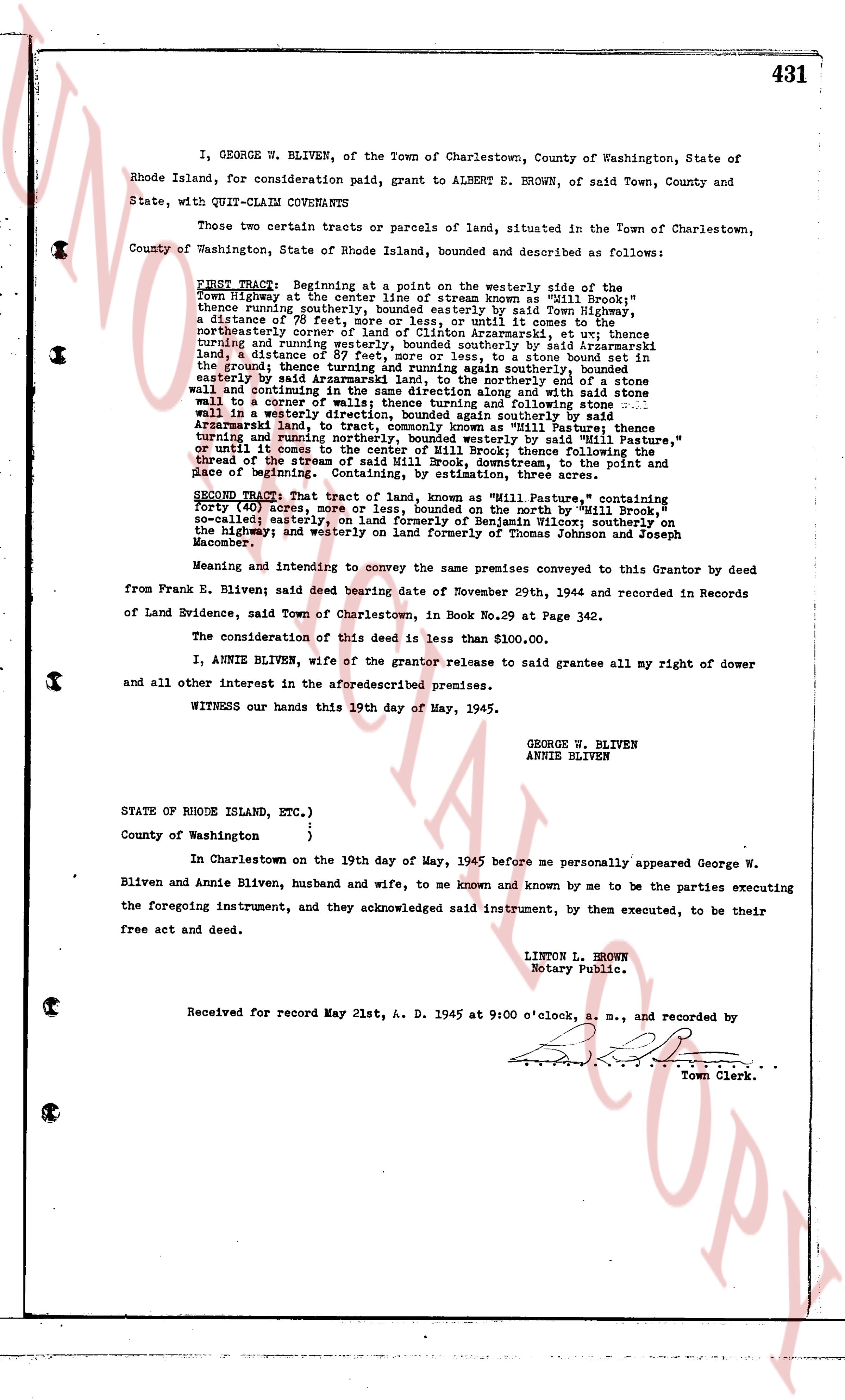
page 1

deed_walker_v1.9_2026-10-10 · the index is the town's own (i2l.uslandrecords.com); transcripts, chains and the assessor's cards are the Perry Machine's reading of it. Where the record we hold runs out, the page says so.