The instrument's own words
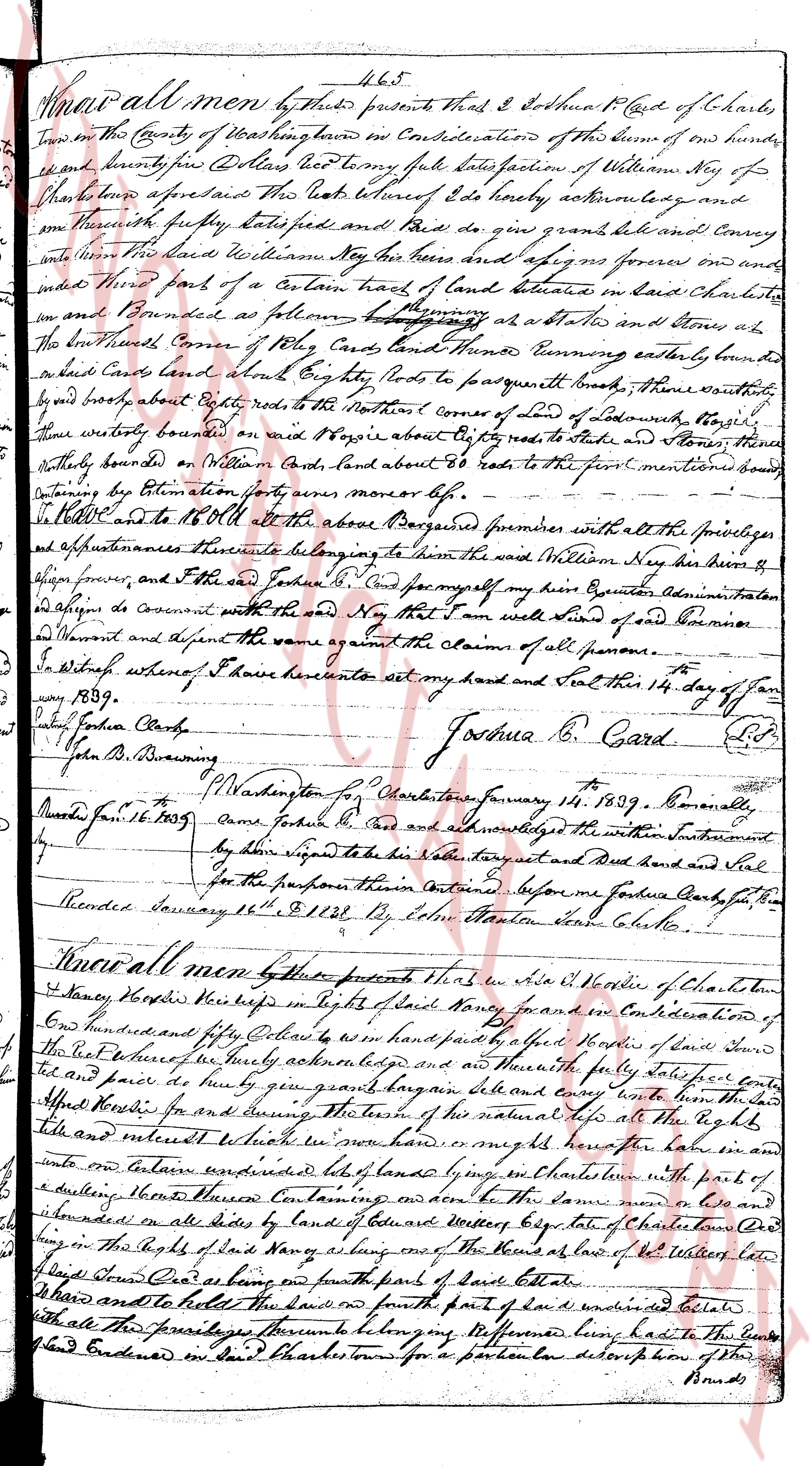
page 1
Know all men by these presents that I & Joshua B. Card of Charls-
town in the County of Washington have on Consideration of the sum of one hundred
and twenty four Dollars and two cents paid unto satisfaction of William Ney of
whom I appear to be the just debtor I do hereby acknowledge and
do promise fully satisfied and paid and do grant and release and Convey
unto said William Ney his heirs and assigns forever one and
one hundred fourth of a Certain tract of land situated in said Charlestown
which is bounded as follows namely beginning at a stake and stone at
the North West Corner of Mr. Card's land and thence turning easterly bounded by
said Card's land about Eighty rods to pasquernut brook thence southeasterly
by said brook about Eighty rods to the Northern Corner of land of Lednum, namely
thence westerly bounded on said brook Eighty rods to stake and stone at
thence southeasterly on Mr. Card's land about Eighty rods to the first mentioned bound
containing by Estimation forty acres more or less.
To Have and to hold all the above described premises with all the privileges
and appurtenances thereunto belonging to him the said William Ney his heirs &
assigns forever and the said Joshua B. Card for myself my heirs executors administrators
and assigns do covenant with the said Ney that I will warrant and defend same
from all persons and against the same against the claims of all persons.
In witness whereof I have hereunto set my hand and seal this 14 day of Jan-
uary 1809.
Joshua B. Card L.S.
[Signature]
John B. Drewing
Charlestown, W. Washington for Charlestown January 14 1809. Personally
appeared Joshua B. Card and acknowledged the within instrument
by him signed to be his act and deed and set hand and seal
for the purpose this instrument continued before me Joshua Card for the
Recorder January 16 1809 by John Martin Town Clerk to
Know all men by these presents that I Asa W. Noble of Charlestown
Towny [illegible] his heirs in right of said land's owner and on Consideration of
one hundred and fifty Cents to be on hand paid by said Joshua B. Card of said Land
and place where he currently resides and and thereby fully satisfied and paid sole for
and purpose do grant bargain sell and convey unto him the said
Joshua B. Card for and during the natural term of his natural life all the rights title
link and interest which I now have or might have for the said land in and
unto as follows a certain piece of land lying in said Charlestown with parts of
a dwelling house containing and above to the same near one and
bounded on all sides by lands of bounded westerly by state of Charlestown and
lying in the rights of said land's owner a long one of the Roads at low of Mr. White's land
and then East and as long as the fourth part of said Estate
To have and to hold the said land or fourth part of said undefined estate
with all the privileges appurtenances belonging to the aforementioned land to the said
Joshua B. Card ended in said Charlestown for a particular description of the said
Bounds
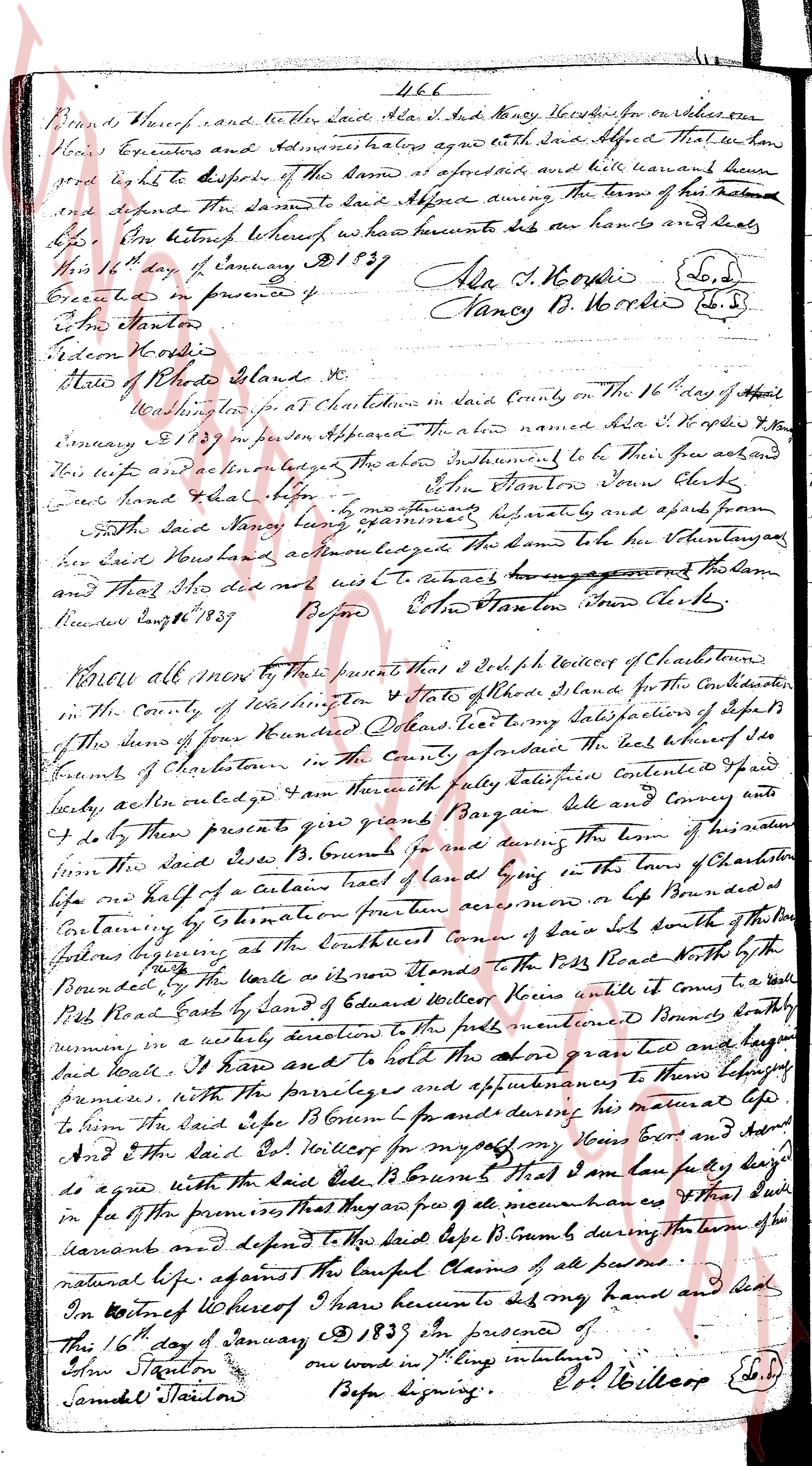
page 2
466
Bounds thereof and further that Said Asa I. & Nancy [illegible] have on this one
hand Executors and Administrators heirs agree with Said Abbed that We have
and right to dispose of the sum at aforesaid side and will warrant have
and defend the Same to Said Abbed during the term of his natural
life. In Witness whereof we have hereunto set our hands and seals
this 16th day of January A.D. 1837
Executed in presence of
Alla S. N. Wordie (L.S.)
Nancy B. Wordie (L.S.)
Edw Stanton
Edmon Wordie
State of Rhode Island &
County of Washington ss
On this 16th day of April
1837 in presence at Charlestown in said County on the 16th day of April
January 1837 in person Appeared the above named Alla S. N. Wordie & Nancy
[illegible] acknowledged the above instruments to be their free act and
their will and action acknowledged the hand to be their signatures
Edw Stanton Town Clerk
and that they [illegible]
Both said Nancy [illegible] appearing separately and spoke from
Faith Said Nancy [illegible] appearing separately and spoke from
her Said Now hand and action acknowledged the hand to be her signature
and That she did not wish to retract her agreement on the Same
Received Eng. 1837
Before Edw Stanton Town Clerk
Know all men by these presents that I Seth Colley of Charlestown
in the County of Washington & State of Rhode Island for the Consideration
of this sum of Four Hundred Dollars paid to my Satisfaction of deposits
of this sum of Four Hundred Dollars paid to my Satisfaction of deposits
Bounds of Charlestown in the County, provide the best witness of said
Bounds of Charlestown in the County, provide the best witness of said
by me on acknowledged I am Honestly fully satisfied contented paid
bodily and I do by these presents give grand Bargain Sale and convey
unto the said Ezra B. Cummins for during the term of his natural
life the Said Ezra B. Cummins for during the term of his natural
life one half of a certain tract of land lying in the town of Charlestown
Containing by Estimation fourteen acres more or less Bounded as
Containing by Estimation fourteen acres more or less Bounded as
follows beginning at the Southeast corner of Said land south of the
follows beginning at the Southeast corner of Said land south of the
following beginning at the Southeast corner of Said land south of the
[illegible] to the Road North by the
Bounded by the line a new Stone Stone to the Road North by the
Bounded by the line a new Stone Stone to the Road North by the
Road Bounded by the land of Edward Wolcott North and it runs to a wall
Road Bounded by the land of Edward Wolcott North and it runs to a wall
Road East by land of Edward Wolcott North and it runs to a wall
running in a westerly direction to the first mentioned Bounds briefly
running in a westerly direction to the first mentioned Bounds briefly
and begin
and begin
and hold the whole land granted and conveyed
and hold the whole land granted and conveyed
premises with the privileges and appurtenances to these belonging
premises with the privileges and appurtenances to these belonging
to term the Said Ezra B. Cummins for during his natural life
to term the Said Ezra B. Cummins for during his natural life
And the Said Ed Wolcott for myself my heirs boys and heirs
And the Said Ed Wolcott for myself my heirs boys and heirs
to agree with the Said Ezra B. Cummins that I am fully lay day
to agree with the Said Ezra B. Cummins that I am fully lay day
in pa of the premises that may as per de maintenance hers that’s’
in pa of the premises that may as per de maintenance hers that’s’
durans and defend to the Said Ezra B. Cummins during the term of the
durans and defend to the Said Ezra B. Cummins during the term of the
natural life against the Lawful Claims of all persons.
In Witness whereof I have hereunto set my hand and seal
this 16th day of January 1837 in the presence of
John Stanton
Samuel Staiton
one word in J. Eng. interlined
Before Signing.
Ed. Wolcott (L.S.)
The page as recorded